• Blog
  • Blog Index
  • Video Work
  • About
Menu

Thomas Bardenett

Urban Planning - Writer - Filmmaker
  • Blog
  • Blog Index
  • Video Work
  • About

Let's Talk About Intersections, Part Two

July 31, 2022

In Part One we looked at intersections as the key to making our streets safer. For Part Two, we will take a closer look at some specific intersections within the City of Syracuse. Now there are hundreds of intersections that could use safety upgrades, but within this post I will be looking only at three. These are not deep dive planning or engineering studies, but instead ideas based on my lived experiences using these intersections and I feel they could be improved. I will also note that there is a geographic bias to these selections, with two being on Grant Boulevard on the Northside of the City. Having grown up just off Grant Boulevard (and having written three blog posts about it - Part I, Part II, Part III), its a good stand in for many of the neighborhood main streets across the City. The third intersection sits right outside of City Hall, which should be used as a model intersection for the rest of the City to follow. 

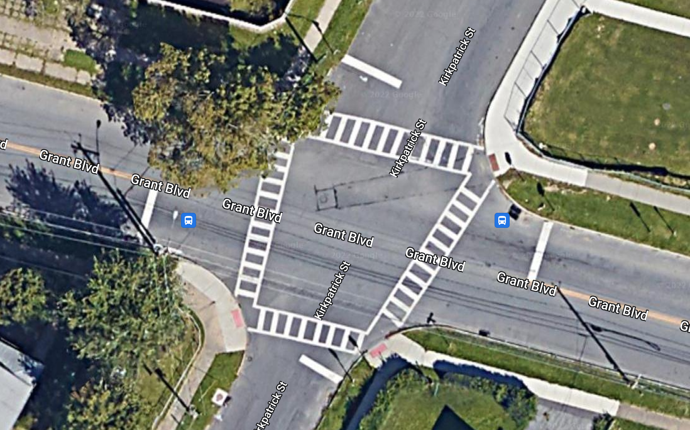
Grant Boulevard / Kirkpatrick Street

Just west of Butternut Circle (which is currently being re-built as a more traditional intersection) sits Grant Middle School, home to around 1,000 students in grades 6-8, on the corner of Grant Boulevard and Kirkpatrick Street. The intersection is controlled by a 4-way stop and sees fairly light traffic. Across the street, the old St. Francis / Gingerbread House campus sits empty, but ready for redevelopment. This intersection is representative of intersections of many around schools within the City and could set a good example for how to increase safety for kids walking to and from school.

Grant - Kirkpatrick.png
Grant - Kirkpatrick - BUMP OUTS.png
Grant - Kirkpatrick.png Grant - Kirkpatrick - BUMP OUTS.png

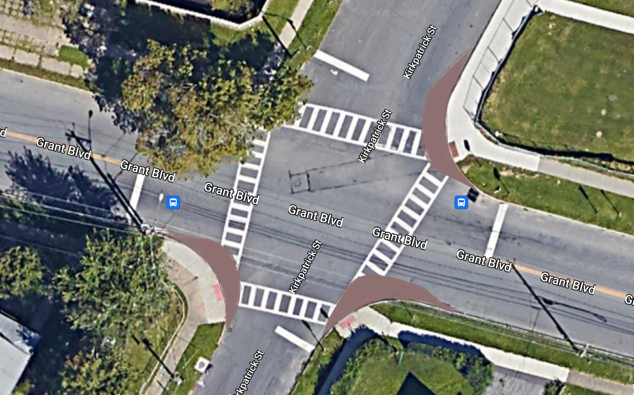
A first option, which would be cheap and easy to install, would be a painted bump out with vertical delineators at each corner. This technique has been used in cities across the country, including extensively in New York City and Hoboken, NJ. Bump outs would help define the corners and ensure people looking to cross are not obstructed by cars parked too close to the intersection. This would also narrow the visual roadway which has been shown to prompt drivers to slow down.The painted bump outs could eventually be improved to be fully curbed and including green space, similar to what can be seen along Water Street as mentioned in the previous blog post.

Grant - Kirkpatrick.png
Grant - Kirkpatrick - RAISED INTERSECTION.png
Grant - Kirkpatrick.png Grant - Kirkpatrick - RAISED INTERSECTION.png

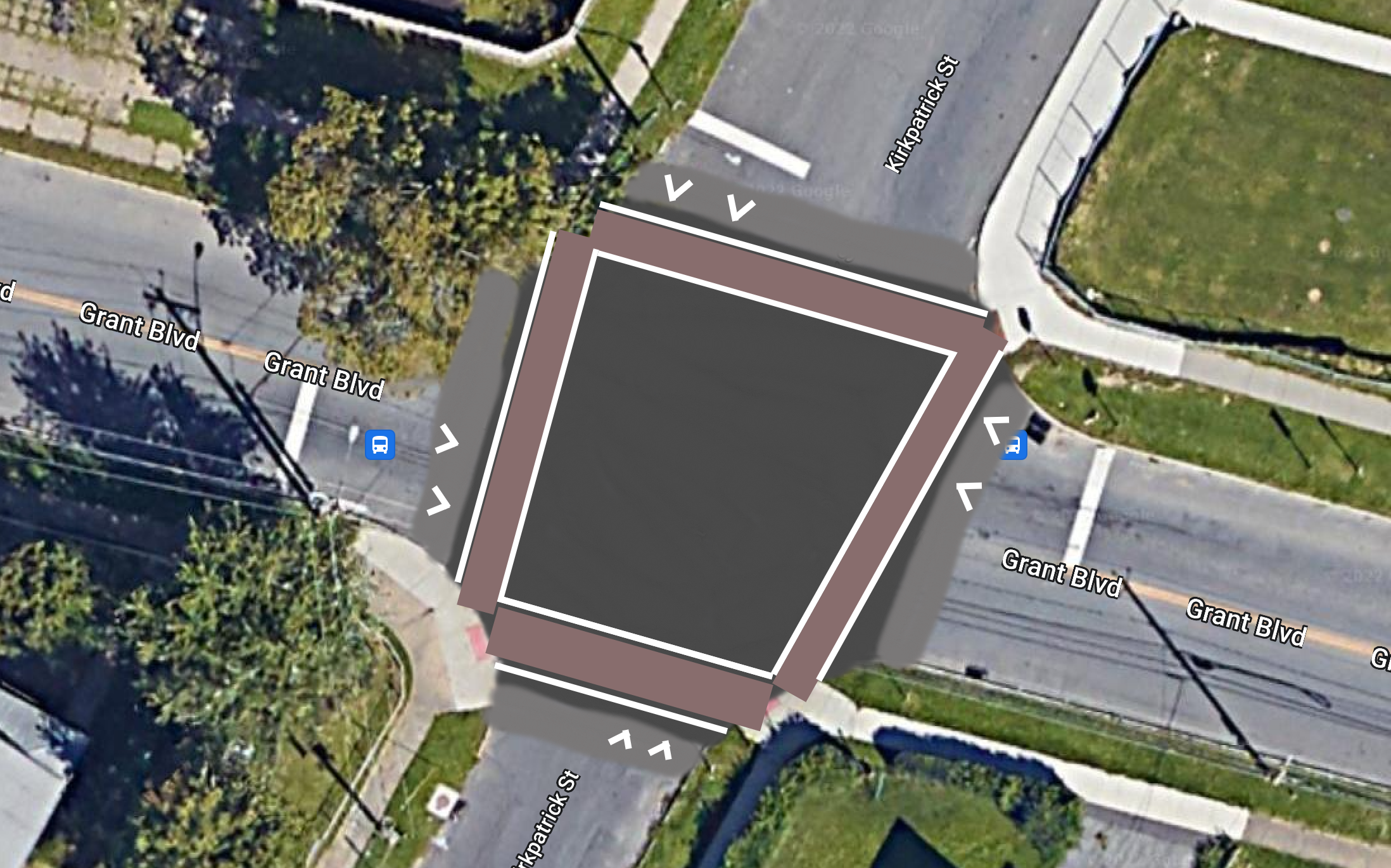
A second, more ambitious option, would be the installation of a raised intersection. The raised intersection slows traffic, similar to a speed bump/table, while also elevating people on foot so they are more visible. The crossing would be further enhanced by utilizing stamped brick pavers to mark the intersection, which acts as an additional traffic calming measure.

Both of these improvements should be explored for intersections around all schools in the City. While many of these schools are set within residential areas with fairly light traffic, they are magnets for kids and families whether school is in session or not. By emphasizing pedestrian movements in this way, the schools and the public park space that surrounds them become even safer destinations for parents to let their kids venture to on their own.

Washington Street / Montgomery Street

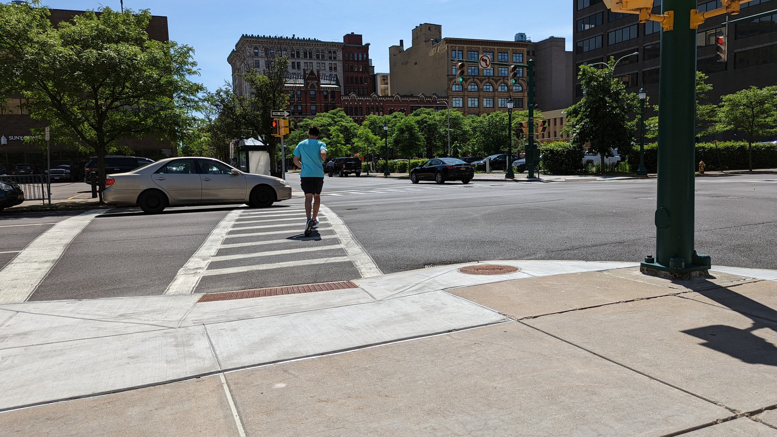
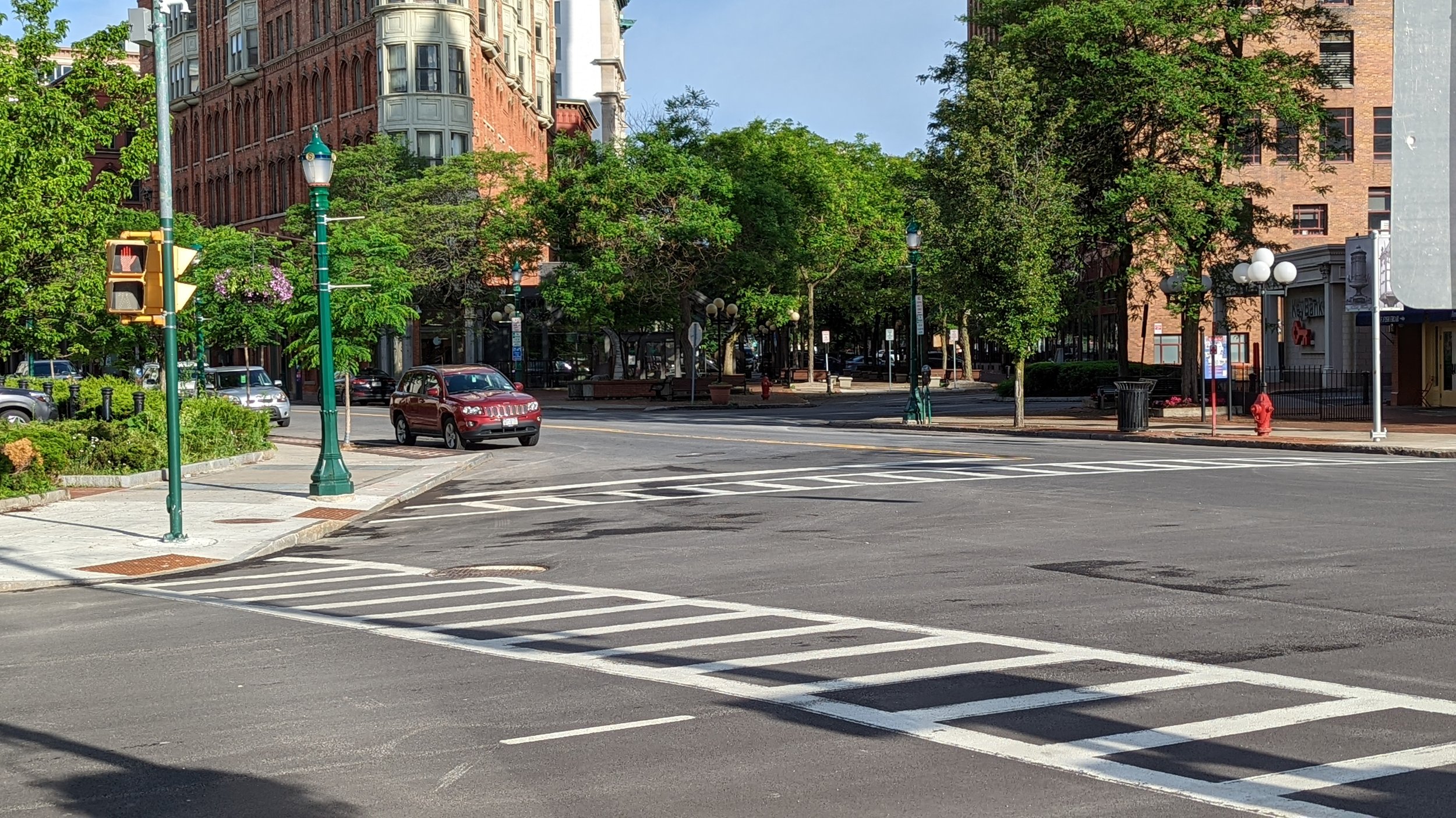
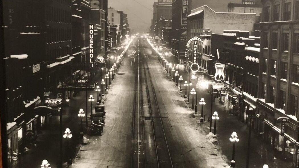
Washington Street reaches a width of 56 feet as it passes in front of City Hall. For a street that only carries around 4,500 vehicles per day, this is absurdly wide. To understand why Washington Street is so wide, you need to know that trains used to run straight down the center of it until the 1930s. When the train tracks were finally relocated to where I-690 presently runs, the City maintained the street at this same width, as many cities have been reluctant to reduce already built rights-of-way. And so here we are with a lightly used street in front of arguably the most important building in the City that creates uncomfortable crossing conditions for people looking to enter its doors. The City is already working to improve this entrance through blocking off a small pull-off area and painting it to create a small, welcoming plaza. But there’s still work to be done when it comes to getting people to its doors.

Washington St  - Montgomery St.png
Washington St  - Montgomery St - BUMP OUTS ONLY.png
Washington St  - Montgomery St.png Washington St  - Montgomery St - BUMP OUTS ONLY.png

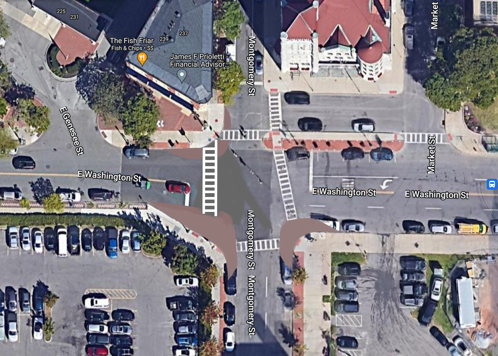
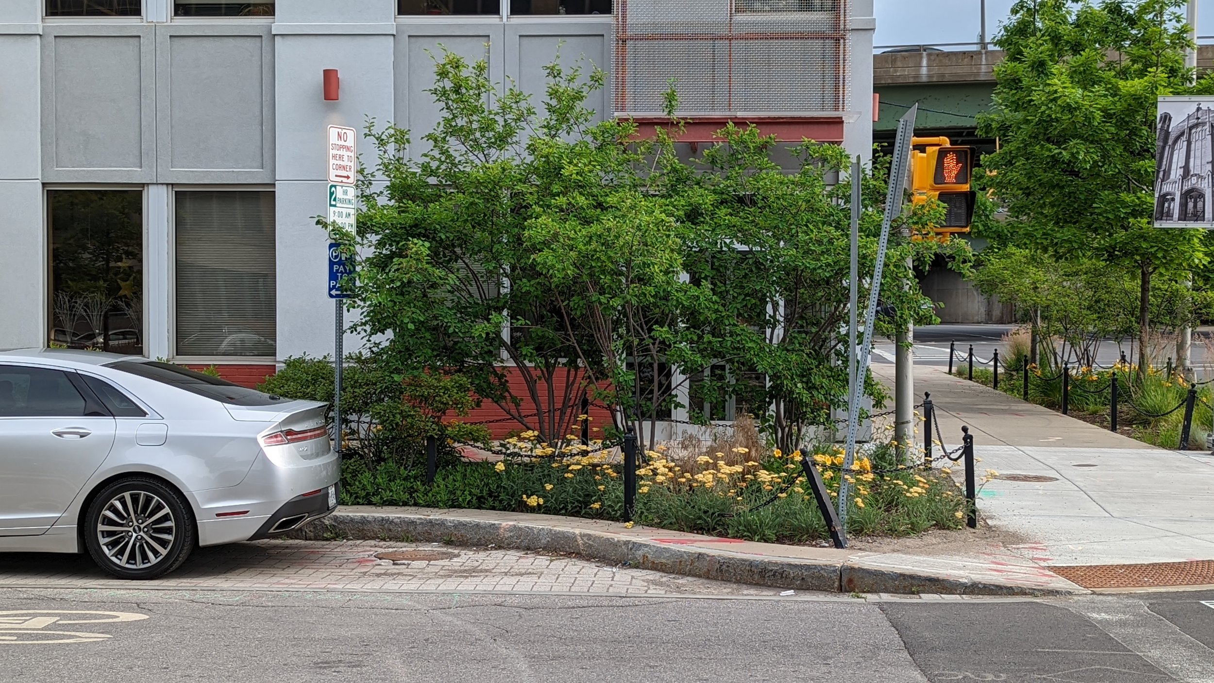
Similar to the first recommendation for Grant / Kirkpatrick, the addition of bump outs, whether painted or curbed, is vital. Currently, people waiting to cross struggle to see cars coming from the west due to the awkward angle the curb line takes. Often, its made even more difficult due to cars parked close to the crosswalks. Extending the curb out will help define where cars are allowed to park, shorten the distance people need to cross, as well as increase the visibility for everyone. This is something easy to do and would help create a more inviting approach.

Washington St  - Montgomery St.png
Washington St  - Montgomery St - BIKE LANES.png
Washington St  - Montgomery St.png Washington St  - Montgomery St - BIKE LANES.png

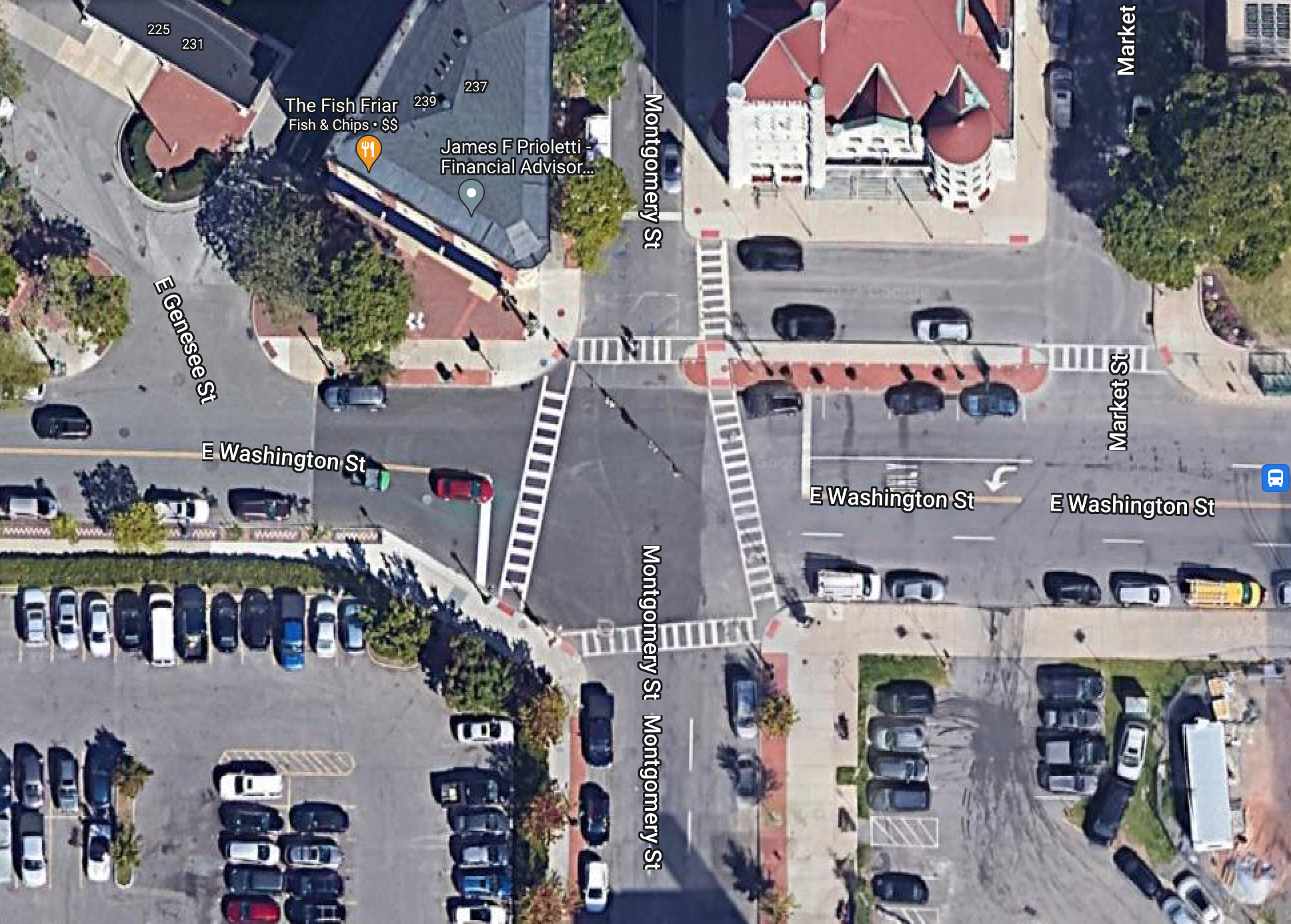
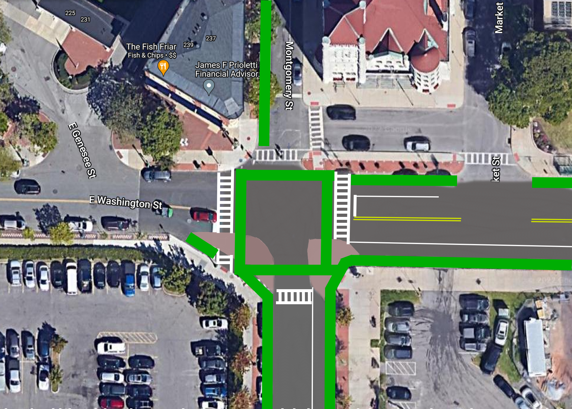
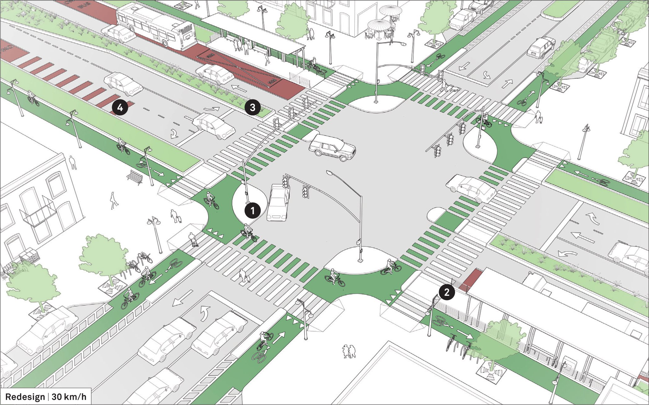
Getting more ambitious, we should go beyond just the intersection and rethink the streets that connect into it. Washington Street could easily be reduced in size for most of its length through Downtown Syracuse. Keeping the street to a single lane in each direction would allow for the addition of a parking protected bike lane along each curb. While there are bike lanes on Water Street and Fayette Street, neither of those streets offer a protected route through Downtown, and do not have the space available for protection to be added, making this an important addition to the network. At the same time, Montgomery Street, south of City Hall, is a three-lane one-way street that sees less than 3,000 vehicles per day. Along the side of City Hall, Montgomery Street is already a single lane one-way street. Keeping the street to those same dimensions would provide space for additional bike lane connections from the Empire State Trail on Water Street into the heart of Downtown. With the addition of these bike lanes, this intersection becomes a prime candidate for the City’s first protected intersection.

Grant Boulevard / Teall Avenue

In the 2021 City of Syracuse Safety Assessment, SMTC identified the Grant Boulevard / Teall Avenue intersection as a priority intersection due to its crash history. Drivers often speed to get through the light, cars move through the slip lanes quickly without looking for people on foot or bike, and the signal timings do not favor easy pedestrian crossings. 

Grant - Teall wide.png
Grant - Teall wide - ROUNDABOUT.png
Grant - Teall wide.png Grant - Teall wide - ROUNDABOUT.png

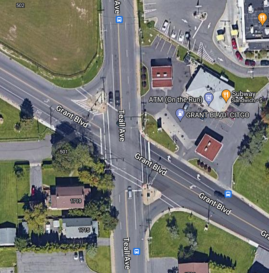
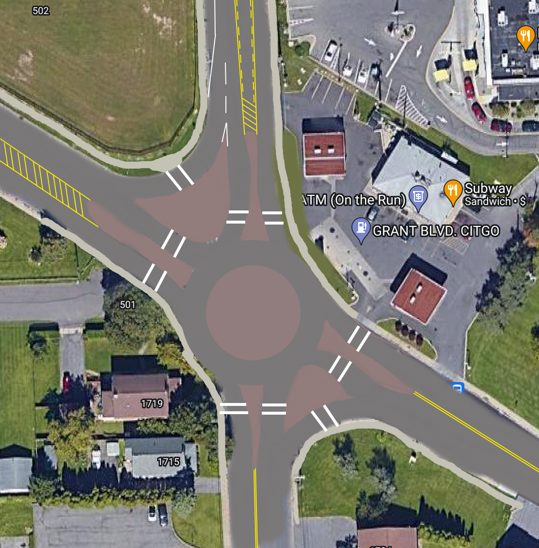
With this in mind, this could be a prime candidate for a roundabout. While the roundabout may require some minor eminent domain to fit, it would allow traffic to move freely at lower speeds and improve pedestrian access. People on foot will be able to cross shorter distances and only need to look in one direction at a time while their visibility to drivers will be increased. Cyclists, meanwhile, will be able to use roundabout in traffic with greater ease as the speeds will be much easier to manage. As part of this change, the Mobil gas station will be required to close two of its driveways, forcing drivers to use the entrances further from the intersection. This, again, will improve safety as drivers will not be competing with intersection movements and have more time to react. While the slip lanes will continue to exist, the pedestrian islands will be enlarged and the lanes will be narrowed. Sidewalks, or potentially a shared use path, should also be added along Woodlawn Cemetery’s property to increase accessibility through the area.

Beyond the intersection, the structures of the streets connecting through the intersection warrant significant changes.Teall Avenue north of the intersection is a four lane roadway with a speed limit of 35 mph. This roadway only sees a little over 5,000 cars per day, a number easily handled by one lane in each direction. Retrofitting this corridor with a road diet (one lane in each directions separated by a turning lane) would handle the traffic levels with ease and would make turning into and out of the businesses along the roadway easier. It would also provide space needed for bike lanes, but the addition of bike lanes would be better paired with a reduction curb cuts that would need more consideration.

These are just three examples of changes, both big and small, that could help improve safety and accessibility in Syracuse. Some can be applied to similar locations across the City, while others are a little more specific to the issues of that location. But the main takeaway should be that we have tools to improve how we move through our city and we should be encouraging each other to think outside the box on how to use them. Brainstorm your own ideas and share them to help start a conversation.

In Walkability
1 Comment

An extra wide Clinton Street allows for cars to travel faster than needed, often resulting in cars coming to a stop on top of the crosswalk.

Let's Talk About Intersections, Part One

June 30, 2022

If you’re like me, seeing a truly well designed intersection is exciting. More than likely you’re not as nerdy as I am and you’ve got other things that keep your attention, only noticing an intersection when there’s an issue. But intersections are the most important thing for a city to get right if they want to keep people safe. This goes for people in cars, on bikes, or simply walking across the street. And for most intersections, we have a lot of room for improvement.

We could look across the Atlantic for inspiration, and some of that will come in later in this piece, but I think it’s more instructive to look at positive examples right here in America.Towards the end of June 2022, articles began to appear celebrating Hoboken, NJ for reaching four years of zero traffic deaths. For comparison, Syracuse, NY, whose population of 148,000 is just under 3x Hoboken’s 54,000, experienced over 40 traffic fatalities in the same timespan. 

So what is Hoboken doing right? 

When it comes to intersections, the City has focused on ensuring that everyone has the ability to see everyone else. This may seem like a simple concept, yet you can walk out to most intersections and find barriers. Signs clutter the corners, cars are parked far too close to the intersection, curb radii are too large forcing pedestrians to cross long distances where they may not be seen by oncoming vehicles, etc. A key way to improve this issue is through “daylighting.”

Daylighting is the process of moving obstructions away from the intersection. You’ll often see signs that state “No Stopping Here to Corner.” These signs are an attempt at daylighting, but with very little influence on driver behavior. Walk in a busy neighborhood and you’ll often see a car parked exactly where it’s told not to. Hoboken has taken the task of daylighting more seriously through their extensive use of curb extensions. This might be paint paired with flex posts to define the space, or, better yet, concrete extensions of the sidewalk. Curb extensions not only enhance visibility of pedestrians and cars, they also slow vehicles down as they enter a tighter space. As humans, we naturally slow down in confined spaces being extra cautious not to hit the sides built up around us. This is why highway lanes are wider than local streets, or at least should be. 

Bike racks and corrals have also been used to daylight intersections, clearing sitelines for drivers and pedestrians while creating a convenient space for cyclists to park.

View fullsize Water Street Bump Out
Water Street Bump Out
View fullsize Water Street Pinch Point
Water Street Pinch Point

Syracuse has some great examples of curb extensions too, they’re just few and far between. But where they are placed, they make a significant difference. A prime example is right outside City Hall on Water Street; concrete curb extensions paired with a planted furnishing zone to provide shade and extra definition to the space. 

Just down the road, Syracuse has made use of another traffic calming technique, the pinch point. While this isn’t at an intersection, its worth noting how the same principles of a curb extension can be applied mid-block where people have a reason to cross, such as getting to a museum or their office.

View fullsize Raised Intersection
Raised Intersection
View fullsize Raised Crosswalk
Raised Crosswalk

Going back to Hoboken, and several other communities across the country including Philadelphia, there have been intersections that have been taken up a notch, literally. Raised intersections, as seen in the above photo found on Streetsblog, bring cars up to the height of the sidewalk, similar to a speed bump. These intersections enhance visibility for people on foot while slowing drivers down. A narrower version of this approach is the raised crosswalk, which keeps people on foot at the higher level of a sidewalk while drivers are forced to slow down to go over the sidewalk. This can be seen in the photo from Cincinnati above.

In the Netherlands, specifically Amsterdam, combinations of raised intersections and crosswalks are seen throughout, typically forcing drivers on the main street to slow down as they turn onto residential side streets.

Now that we’ve made the jump to some international examples, let’s take a look at probably the best design for intersections for all users; the Dutch intersection. A more universal name for it is the protected intersection, as it creates barriers that protect both cyclists and pedestrians as they use the intersection.

View fullsize Syracuse Bike Intersection
Syracuse Bike Intersection
View fullsize Dutch Intersection
Dutch Intersection

Let’s take a look at the two photos above. The one of the left is from Syracuse where two bike lanes meet in Downtown. This is typically how American cities handle this type of intersection, with both lanes starting and ending at the intersection with no real separation between cars and bikes. Now when you look at the graphic on the right, you’ll see an extra level of separation. Not only is the bike lane protected, but a concrete island stretches between the two crosswalks forcing drivers to take wider, safer turns. At the same time, cyclists and pedestrians are moved up further in front of drivers before they cross. This gives them a chance to begin crossing before cars get into the intersection. Ottawa, Canada has been at the forefront of this style of intersection in North America, with some even appearing before bike lanes are installed.

One thing these intersections require is the removal of curbside parking, either by eliminating parking all together or creating floating parking lanes, which Syracuse has struggled to embrace in the past. But things are changing and the City is putting forth a true effort to create safer bike infrastructure. 

While you may not find intersections as interesting as I do, it's important to recognize when they’re done well and what benefits they bring. Create spaces where people of all ages and abilities feel safe to move around the city. Quiet your streets by slowing down cars and encouraging other modes of travel. Embrace an all around healthier city and self by creating safe spaces. We may not officially have a Vision Zero policy in Syracuse, but advocating for and implementing these improvements can get us on our way there.

In Part Two, I’ll take a look at some specific intersections to explore what we might be able to do to improve them for everyone.

The intersection of Washington and Montgomery in Downtown Syracuse was originally due to train tracks that ran down the center of the street. Now pedestrians are pushed off to the side as the prepare to cross, out of sight of cars and obstructed by trees, lamps, and signage.

In Transportation, Walkability, Urban Planning
Comment

A Few Days in Cincinnati and a Few Lessons for Syracuse

March 31, 2022

Whenever I travel I find myself focusing on how the cities I’m in function. I always enjoy myself the most when I’m walking the streets, riding a bike, or riding transit somewhere, which lets me experience the city at a more human pace. When you’re driving or Ubering everywhere you go, you never get a sense of where things are or how they connect with one another.

In the middle of March 2022, I traveled to Cincinnati, Ohio for the first time. A city that is rarely at the top of urban planner’s thoughts when it comes to progressive policies and projects, yet it has quietly built some truly pleasant human scale environments on the sturdy bones of its historic core. Downtown Cincy and the Over the Rhine (OTR) neighborhood offer walkable streets, plentiful dining and shopping experiences, as well as access to the city’s major league sporting venues. While these two neighborhoods only make up a very small part of the city as a whole, they offer up some ideas to other Rust Belt cities on how to embrace your history and make it a livable space moving forward.

DORAs and Plazas

A recurring theme in many of my articles is the need to provide safe, open spaces for people to enjoy. This is especially true during the past few years during the COVID-19 pandemic, which has made eating and drinking outdoors a much more attractive and safer option for many. Cincinnati, including many of its suburbs, has taken this to heart, opening up at least 17 DORAs, which stands for Designated Outdoor Refreshment Areas. DORAs are pedestrianized streets lined with bars and restaurants that allow visitors to move freely between establishments with their drinks in hand, as long as the drink is in an official DORA cup. Each DORA is set up to meet the needs of the businesses and communities they sit within. During my trip to Cincinnati, I visited the most well known DORA in the region, the Banks, which sits between the stadiums for the Bengals and the Reds right on the Ohio River. The main street, Freedom Way, is blocked off to traffic year round, allowing for bars and restaurants to add seating and games. A few bars have walk-up windows allowing easy access for ordering. We happened to be there on St. Patrick’s Day when it was 75 degrees out, so the entire area was filled with people enjoying the sun. The one downside of the Banks is that you’re forced to cross two five-lane one-way streets and a bridge across I-71 in order to get there from the rest of Downtown Cincinnati. The whole area is also built on top of a massive parking garage that is clearly meant for game days and not much else.

Beyond the DORAs, many bars and restaurants in Cincinnati have benefited from small plazas created by closing off ends of streets. Not only does this provide additional seating space for businesses, but it also acts as a traffic calming device. Now cars are unable to speed through the neighborhood, while people walking or riding a bike can easily pass through. This sends a clear message that cars are guests within the neighborhood.

Syracuse can easily implement similar spaces throughout the City. Armory Square, which has enjoyed successful weekends of closed streets, is the perfect candidate for a DORA program. We don’t need to look too far for an example of how that might work. The City of Oswego is currently considering a plan to let people in their Downtown area walk freely between bars and restaurants as long as their drinks are in pre-approved, logo ladened containers. This “Social District” doesn’t go quite as far as closing down streets, but Syracuse already has that in place during the summer months. If anything, Syracuse needs to consider closing those central blocks of Armory Square on a more permanent basis to create a true destination.

Smaller blocked off plazas, similar to the image above, could be implemented across the City. Blocks around Westcott, or at the five-way intersection of Hawley/Catherine/Green in the Hawley Green neighborhood, or by the Byrne Building in Downtown. The City should put out a call to businesses and neighborhoods asking for input on where these traffic calming plazas would be desirable. All it takes is some paint, planters, and chairs to transform the end of a block into an enjoyable place to be.

Rooftop Access for All

Having lived in Syracuse for the vast majority of my life, it’s surprising that I really haven’t had many opportunities to see Downtown from an elevated vantage point. You of course have the beautiful views from a number of parks around the City (Schiller, Burnett, and Upper Onondaga come to mind), but its surprising that we haven’t looked for other opportunities to embrace an urban rooftop view. In Cincinnati I lucked out in finding a few rooftop bars and restaurants to take in the sights. One, Rhinegeist Brewery, repurposed a massive space in an old warehouse along with its rooftop, offering up some spectacular views of the industrialized neighborhood against the hills.

Syracuse, like Cincinnati, is filled with old warehouses and factories looking for new life. I’ve written about a new vision for the old warehouses around Washington Square Park, encouraging local breweries to move into the neighborhood. It would be a missed opportunity if we didn’t open up access to the rooftop of the old Moyer carriage factory and create a unique space around the house at its top. The views would offer a truly unique experience. 

Some will argue that rooftop access doesn’t make much sense in the snowiest city in the country, but the poor weather conditions aren’t nearly as bad as people make them out to be. Providing some cover and heated spaces would be enough to make most days enjoyable. Even if a bar or restaurant decides to only keep the rooftop open in the warmer months, they’ll still reap the benefits of the expanded space and become true destinations.

Rethinking Free Transit Loops

The Cincinnati streetcar, the Bell Connector, has been controversial over the years. Its ridership levels have never met the lofty goals its supporters set. Its route only connects Downtown Cincinnati with the nearby OTR neighborhood. Ridership fell when a fee was added for rides. But once the streetcar was made free again in 2020, ridership has picked up and has continued to grow. It’s not a perfect system by any means, but it does a lot more good for riders than the Syracuse Syrculator ever could. The Bell Connector links some densely populated residential areas to employment and entertainment centers. The stops are built out with shelters and countdown clocks, making it comfortable to wait. The Connector also runs from 7:30am to 11:30pm, making it possible for workers to actually use it for commuting purposes. 

Syracuse, with its much smaller physical footprint and denser development pattern, may not really need a transit loop. Instead, Syracuse should concentrate on implementing BRT. The proposed BRT routes would act in a similar manner as the Bell Connector, connecting densely populated residential neighborhoods to employment and entertainment centers. While BRT would not be free, the new $1 fare for Centro already makes the trip cheap and convenient for regular riders, visitors, and anyone who just decides to try out the system. 

Syracuse can learn a lot from other Rust Belt cities. Next time you take a trip to one, think of what we can borrow and improve upon to help make Syracuse a more livable city.

In Walkability, Urban Planning
Comment

Downtown Syracuse after a heavy snowfall

Cities Don't Have to be Loud

January 31, 2022

One of the things that stands out after a heavy snowfall is just how quiet the whole world becomes. You can hear the gentle crunches of the snow beneath your feet when you walk outside. The first run of the plows breaks the stillness, but they still feel muted. The rest of the world is still waking up and those that are up often choose to stay home until the roads are clear. It’s as if the world is covered in a blanket, resting.

Snow acts as a natural muffle as it absorbs noise, but it is not the only reason these snow days help to quiet a city. By choosing to stay home to avoid the snow covered streets, we help remove one of the biggest audio nuisances around; your car. 

View fullsize original_96cc2c14-b514-443b-9abc-1da2984159ff_PXL_20210202_123457176.jpeg
View fullsize original_d355aa14-3a93-4573-b437-4a8673505043_PXL_20210202_124251947.jpeg
View fullsize PXL_20201229_130158921.jpeg
View fullsize PXL_20220108_002420946.jpeg

We often think of cities as noisy places filled with traffic and construction, but we forget that there are plenty of cities that are snow storm quiet all year round. The one thing they have in common is that they de-prioritize cars in their transportation networks. To see why this policy matters, we first need a quick run down of how decibels are measured.

Decibels are measured logarithmically, which means that if something is 10 decibels louder, it is in fact 10 times louder. If something is 20 decibels louder, it is 100 times louder, and so on. Extended exposures to sounds over 70 decibels can lead to hearing damage.

 So let’s take a look at some decibel levels of common occurrences in an urban setting:

  • Normal conversation: 60 decibels

  • Busy street: 75-85 decibels

  • Lawn mower: 94 decibels

  • Motorcycle: 105 decibels

  • Car horn: 110 decibels

  • Ambulance siren: 112 decibels

  • Diesel truck accelerating: 114 decibels

If you’re driving through a city you may not notice your contribution to this urban noise pollution as cars have become a sort of isolation chamber on wheels, but when you’re walking or riding a bike you notice the increase in noise immediately. Adding more cars on the road also increases the likelihood of emergency vehicles finding themselves stuck in traffic, resulting in prolonged exposures to dangerous decibel levels for everyone outside of a car.

Cities don’t have to be this way. Cities in the Netherlands are dramatically quieter than their American counterparts, primarily due to their transportation policies. By emphasizing pedestrians, cyclists, and public transit while slowing down the private cars that are in use help reduce the amount of noise pollution on an average city street. You can see this in more detail in the video below by Not Just Bikes on YouTube.

While larger changes to our transportation network may take time, there are plenty of things we can do now to start the transition and bring down the noise.

Street trees and other urban vegetation help to absorb sound. They have also been shown to slow down vehicles by visually confining the space, forcing drivers to increase their attentiveness. On top of all of that, they make walking a much more pleasant experience by providing shade, cover from rain, and a visually interesting journey. Cities should ensure that all street and sidewalk improvements are coupled with an evaluation of their street tree canopy. 

Prioritize clearing sidewalks and bike paths during winter storms to encourage their usage. Walking through the snow can be a challenge for many people, especially if it’s deeper than a couple inches. Cities like Syracuse and Rochester, NY are making serious strides when it comes to clearing sidewalks during the winter, but they still play second fiddle to the roadway clearing programs these cities have had in place for the better part of a century. If we begin elevating sidewalks and bike lanes to the same level as vehicle lanes, we may get closer to the Finnish ideal of prioritizing the most efficient forms of transportation over personal vehicles. 

We might not want to be stuck in a snow globe all year round, but there’s no reason our cities can’t get closer to the peace and quiet we hear during those early winter mornings. Quiet cities let us enjoy the little things just a bit more.

About 27 percent of Syracuse is covered by tree canopy, which is below average for cities east of the Mississippi River.

In Syracuse, Urban Planning, Walkability
Comment

The Holiday Season Really Celebrates Walkability

December 14, 2021

What do you picture when you think of the holiday season? Lights? Busy sidewalks? Store windows packed with decorations and gifts on display? A Christmas tree in the heart of the city? Are you seeing a show at the one fancy theatre downtown? Or are you in a park having a snowball fight in your neighborhood?

Now think about your city, or town, when the holidays aren’t around. If you live in a typical American city, that hustle and bustle downtown will fade away. You probably won’t think about the shops on Main Street as much, if at all. And you’ll be back to thinking of road trips and spending time in your car. I’m not sure about you, but when I think of a picturesque holiday scene everyone is walking around, not stuck in a car in traffic.

We might not always realize it, but many of the traditions we celebrate during the holiday season are in fact a celebration of an urban experience we no longer allow to be built. It's an experience of walkability. 

Jeff Speck, the author of Walkable City: How Downtown Can Save America, One Step at a Time, identifies four keys to making a city walkable:

  1. Provide a proper reason to walk

  2. Make the walk feel safe

  3. Make the walk comfortable

  4. Create an interesting walk

Let’s think about how our holiday traditions fit into these categories.

3ca3b456-a083-4efa-95c4-30106e4cf2e9-large16x9_SalinaChristmas.jpeg
christmas-downtown----1952-9892ac5fbd072ea5.jpeg

A Reason to Walk

There’s one simple answer to this: shopping. While we can argue about the merits of consumerism, there is a joy that comes out of shopping for many people. Window shopping, trying on clothes (whether you can afford them or not), buying gifts for people we love, each offer a type of joy and a reason to shop. 

Before the advent of the shopping mall or the super-center, all of our shopping took place Downtown or in neighborhood shops. Now, we celebrate this shopping tradition through Small Business Saturday and other locally focused events aimed at bringing shoppers back Downtown. 

Christmas villages famously pop up across Germany, while many American cities have adopted their own versions, including New York and Chicago. New York's Bryant Park, Columbus Circle, and Union Square evolve into shopping and entertainment centers filled with small shops, specialty food vendors, and drinks. They're a Christmas tradition for many residents and visitors that can only really be accessed on foot.

View fullsize IMG_20191218_170508.jpeg
View fullsize IMG_20191216_173922.jpeg
View fullsize PXL_20211213_230242367.jpeg
View fullsize PXL_20201212_220617826.jpeg

A Safe Walk

An under-appreciated benefit of the holiday lights is the added safety they can bring to someone walking along the sidewalk. Additional lights provide added visibility to pedestrians, making them easier to see for drivers. This has been identified as key safety improvement by Safe Routes to School organizations.

Street lights have also been shown to reduce crime. One study that looked at public housing developments in New York City found that developments that had new lighting installments saw “index crimes” conducted outside at night reduced by 36 percent compared to the other developments. 

Downtown Syracuse - Aiden Media
Downtown Pittsburgh - Dave DiCello Photography

The added crowds add another form of safety for pedestrians. Jane Jacobs often discussed the benefits of having eyes on the street, reducing the likelihood of crime happening for fear of being caught. Shop keepers, shoppers, and just people out for a walk can all look out for one another as they enjoy the day. 

The holidays are also a time to celebrate our public squares, which are often the safest place for a pedestrian to be. Many cities and towns build ice skating rinks within their parks and plazas, providing places to gather safely away from traffic. It's no surprise that these are the places where holiday pop-up shops, Christmas trees, and menorahs are erected.

A Comfortable Walk

Downtown streets, unlike streets in almost any other neighborhood in most American cities, benefit from wide, spacious sidewalks. Pedestrians can walk in groups with friends and families without being forced to walk single-file past strangers. Making walking a social experience creates a comfortable environment for everyone.

While the weather in December may impact the level of comfort for some, trees, awnings, and a cup of hot chocolate should be enough to keep most pedestrians comfortable during the day. Additional accommodations may be necessary at night, or if you’re looking to enjoy an outdoor dining experience, which should be considered more by cities - especially as the pandemic continues through this winter. 

View fullsize PXL_20211202_120429425.MP.jpg
View fullsize PXL_20211202_120440066.MP.jpg
View fullsize PXL_20211203_220432366.jpg
View fullsize PXL_20211203_220520996.jpg
View fullsize PXL_20211206_110329559.jpg
View fullsize PXL_20211209_110558286.jpg

An Interesting Walk

The most obvious boost the holidays give to walkability is in the creation of an interesting walk. Shops, restaurants, and even residents decorate their property with lights, signs, and displays. Downtown Syracuse, along with many other cities, hold a window decorating competition to drum up excitement for the holiday season. New York City is filled with over-the-top displays every year, including light shows that stop people in their tracks. 

Nearly every city in the country has a central Christmas tree surrounded by other holiday lights, drawing large crowds for lighting events, bringing the most interesting thing in the world to our Downtowns - other people. Humans are social creatures and we can’t help but be fascinated by other people. Bringing people together for large events, or just adding crowds to a sidewalk, intrigues us.

We shouldn’t have to wait for the holidays to enjoy walkability. There’s no reason we can’t add light and warmth to our cities year round. The next time you’re watching a cheesy holiday movie set in a small town where seemingly everyone is in the town square all day, or setting up a small Victorian Christmas village under your tree filled with carolers and horse drawn sleds, think about the ways we can bring that walkability and urbanism to our own cities and towns. We can bring some of that magic to life.

In Walkability, Urban Planning
Comment
← Newer Posts Older Posts →

Recent posts

Featured
Carousel.jpg
May 27, 2025
Destiny USA and the City
May 27, 2025
Read More →
May 27, 2025
PXL_20240805_141743149.jpg
Jan 1, 2025
All Cities Are Beautiful
Jan 1, 2025
Read More →
Jan 1, 2025
PXL_20241005_135224129.jpg
Nov 6, 2024
A Healthy Future for the Regional Market
Nov 6, 2024
Read More →
Nov 6, 2024
PXL_20240728_191254239.jpg
Jul 31, 2024
Renters Matter, Too
Jul 31, 2024
Read More →
Jul 31, 2024
Vista view.jpeg
Mar 21, 2024
The Valley of the Sun - A Land of (Sub)Urban Extremes
Mar 21, 2024
Read More →
Mar 21, 2024
Manlius Cinema.jpeg
Jan 31, 2024
The Movie Theater at the Urban Core
Jan 31, 2024
Read More →
Jan 31, 2024
Clinton Square Christmas Tree at night.jpeg
Nov 30, 2023
The Case for a Holiday Village
Nov 30, 2023
Read More →
Nov 30, 2023
PXL_20230817_220739294.jpg
Oct 31, 2023
The Walk: To Middle Ages
Oct 31, 2023
Read More →
Oct 31, 2023
Ballpark.jpeg
Sep 7, 2023
The Walk: To the Ballpark
Sep 7, 2023
Read More →
Sep 7, 2023
PXL_20230813_213112525.jpg
Aug 14, 2023
The Walk: To Tipperary Hill
Aug 14, 2023
Read More →
Aug 14, 2023
Arts and Crafts Festival 2023.jpeg
Jul 31, 2023
The Walk
Jul 31, 2023
Read More →
Jul 31, 2023
PXL_20230515_144325643.jpg
Jun 21, 2023
Lessons from the North
Jun 21, 2023
Read More →
Jun 21, 2023

Powered by Squarespace