• Blog
  • Blog Index
  • Video Work
  • About
Menu

Thomas Bardenett

Urban Planning - Writer - Filmmaker
  • Blog
  • Blog Index
  • Video Work
  • About

Growth in CNY: Housing

October 30, 2022

I had planned to end 2022 with a blog post looking ahead to the future and ways that CNY, and more specifically Syracuse, can encourage growth in sustainable way. I have had conversations over the years saying that Syracuse would be a great city of 250,000 people, with just small tweaks and changes to our built environment. Now, at the beginning of October 2022, these conversations take on a new urgency, with the announcement of Micron investing up to $100 billion just north of the City and bringing 9,000 high paying jobs, with up to 40,000 additional jobs in related industries. So to finish up my 2022 blog series, I plan to address this growth in three parts: Housing, Mobility, and Culture & Amenities.


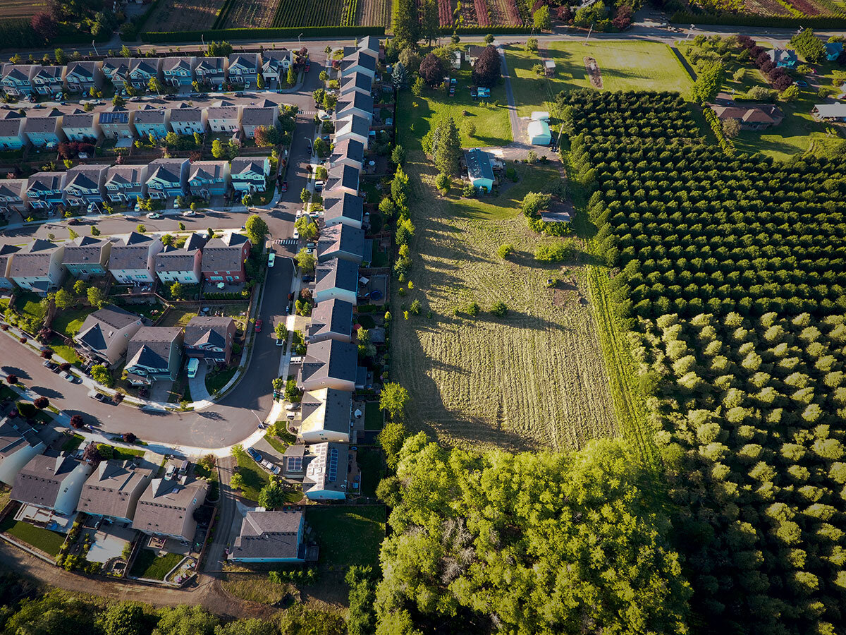
Syracuse, Onondaga County, and Central New York have not experienced any significant growth in 50 years, meaning we have not seriously considered how we should grow and in what places. Onondaga County’s built out footprint has steadily increased over this time while its population has stagnated. This is unsustainable in the long term, and detrimental to our environmental, fiscal, and individual health. As one developer noted in a recent Post Standard article, many of the suburban zoning codes require that any new development take place on one acre lots, leading to significantly larger and more expensive housing than is needed. That same developer is asking for zoning changes to allow up to three homes per acre, but even that is still far too large and spread out for sustainable growth. 

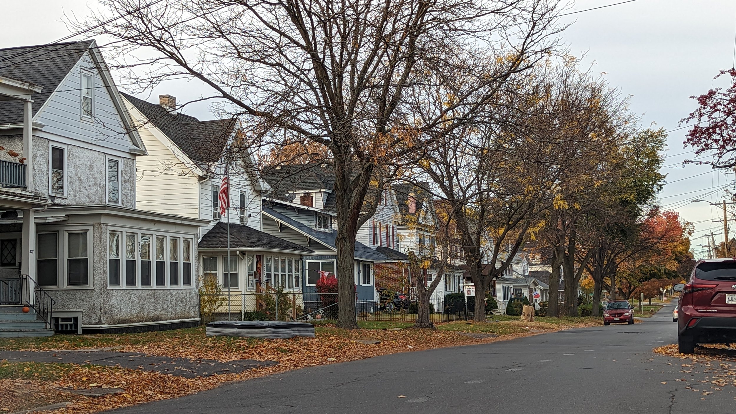
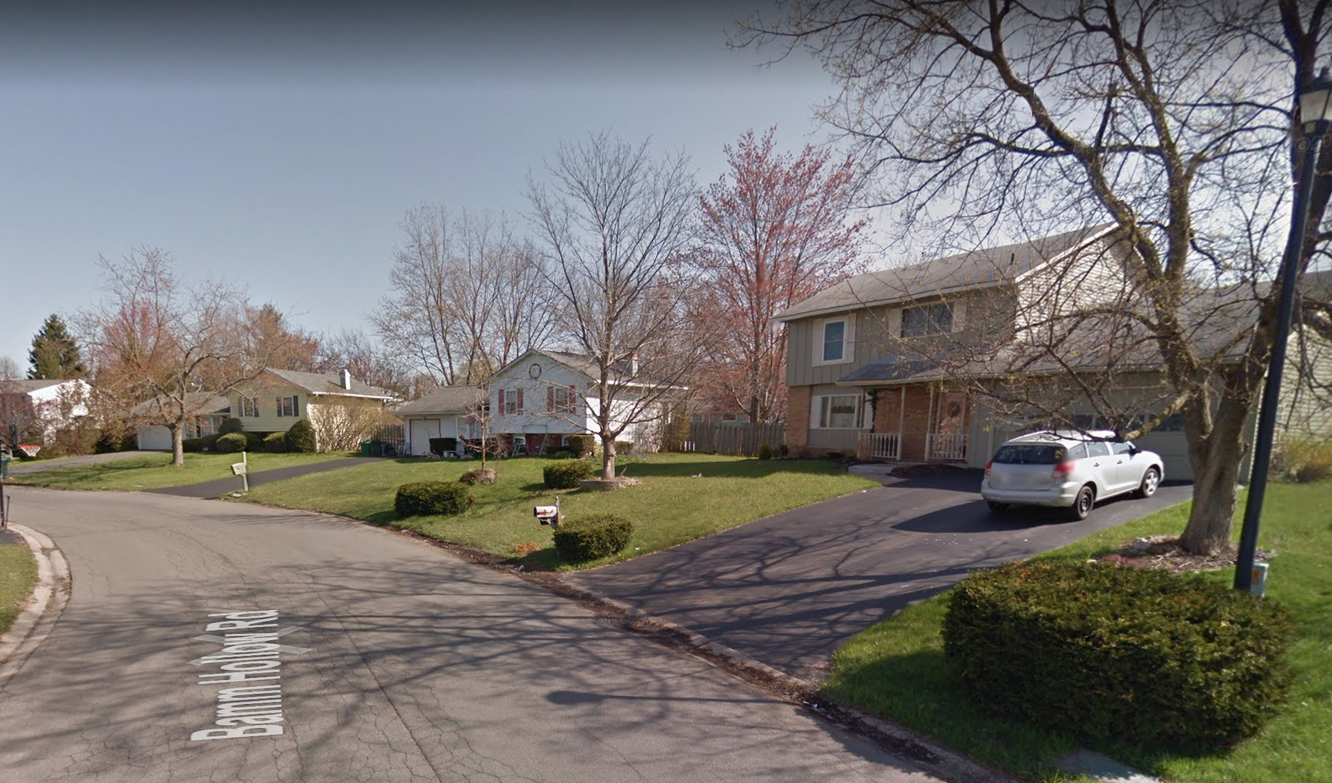
To give an example, in 2020, the average household size for owner occupied homes (primarily single family homes) was 2.46 people, for renters that drops to 1.97. At three homes per acre, that’s roughly 4,600 people per sq mile. That’s better than most suburban towns in Onondaga County presently, but even if you look just south of the White Pines Commerce Park, where Micron will soon be located, many of those developments have blocks with densities of four homes per acre, and over 6,000 people per sq mile. 
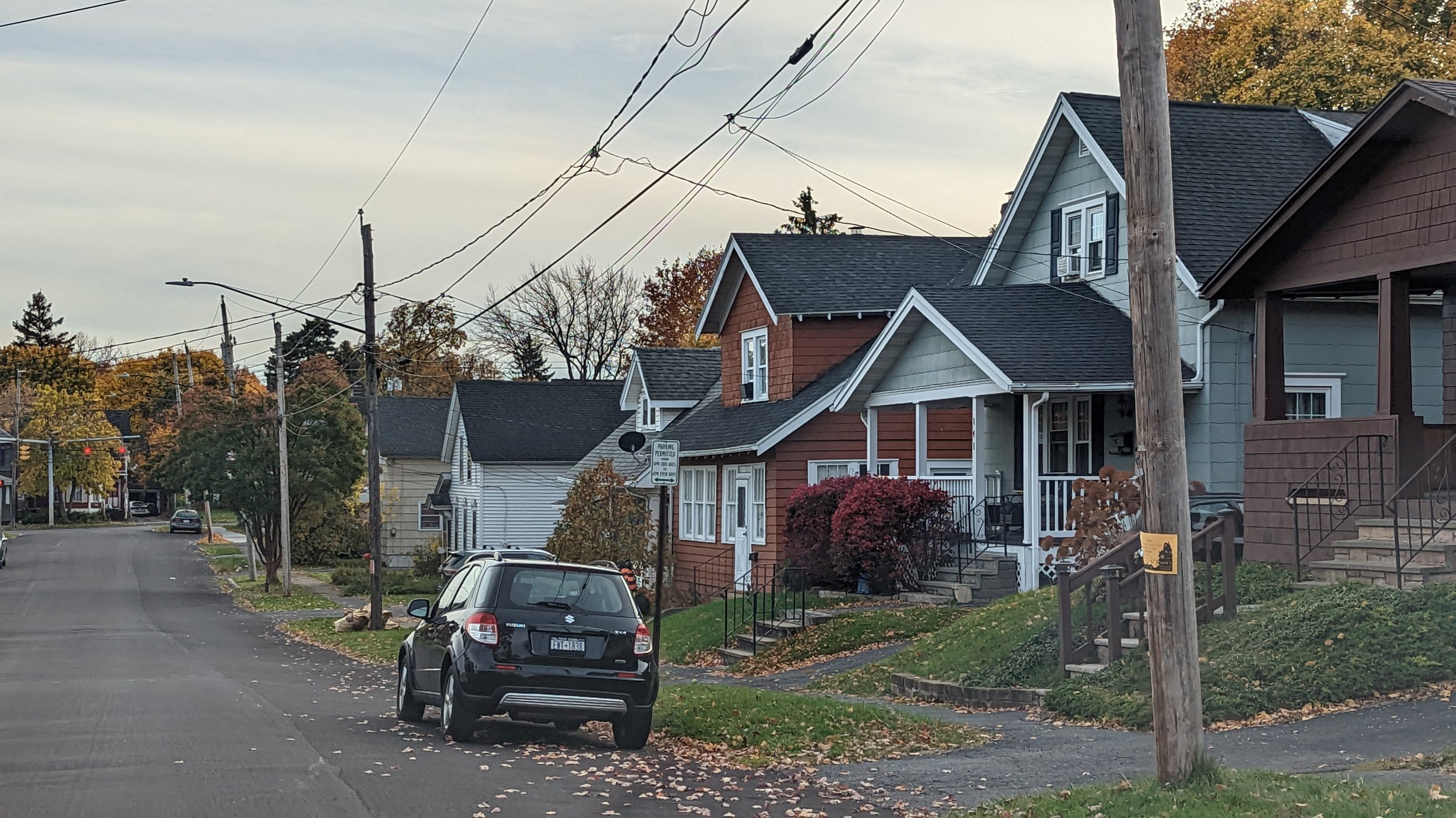
Darlington Rd - Syracuse
Wadsworth St - Syracuse
Bamm Hollow Rd - Clay
Darlington Rd - Syracuse Wadsworth St - Syracuse Bamm Hollow Rd - Clay

Currently, Syracuse has a population density fo around 5,700 people per sq mile, for a total population around 148,000. For Syracuse to reach a population of 250,000, the City as a whole will need an average population density of roughly 10,000 people per sq mile (actual residential blocks being a bit denser than that to account for park land, cemeteries, commercial areas, etc.). That may sound like a lot, but let’s look at a few examples of neighborhoods that reach that same level of density on the City’s Northside. The block bordered by Darlington Rd, Grant Blvd, Mayer St, and Listman Ave has roughly eight homes per acre, with a population density of 11,000 people per sq mile. Or if you move a few blocks west, the block bordered by Wadsworth St, Grant Blvd, Woodruff Ave, and Listman Ave houses a few more two-family homes, and has a density of over 13,700 people per sq mile. Compared to many larger cities in the country, these two blocks are nearly suburban in nature, yet provide a level of density that helps support nearby neighborhood businesses on Grant Blvd and promotes a fair bit of walkability. These smaller homes are also more affordable for most people and easier to maintain. With the current suburban zoning regulations, neighborhoods of this size are impossible to build. 

So let’s take a look at places within the City of Syracuse and the surrounding towns that are ripe for development to help promote both this gentle density and higher density developments, helping to prevent the continued sprawl that threatens the region.

City of Syracuse

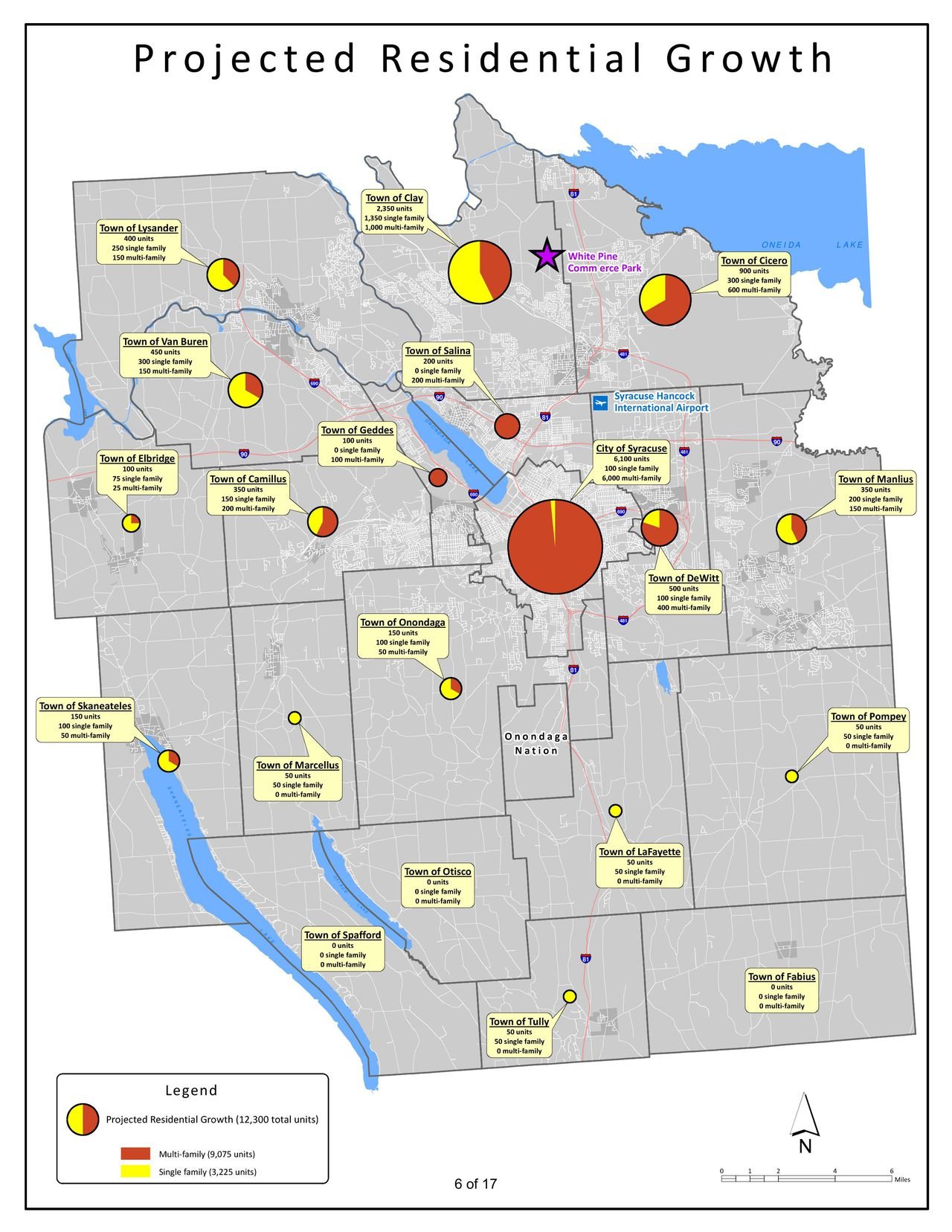
Let’s start with the City itself. In meetings with Micron, Onondaga County laid out plans to build over 9,000 new homes in the next 20 years (above), with over 6,000 of those homes coming to the City of Syracuse. It's natural for the City to absorb a large share of the new housing, and it's encouraging that the County overall views multi-family housing as the primary driver of this new expansion. But let’s look at a few different neighborhoods that can play a big role in adding density without displacing others.

Downtown

Downtown Syracuse has grown into a full blown residential neighborhood over the past two decades, and the trend is not slowing down. With I-81 coming down, more land between Downtown and University Hill will be freed up for development, which should be primarily mixed-use in nature. But there is already plenty of land to build on Downtown, it just happens to be covered with parking lots.

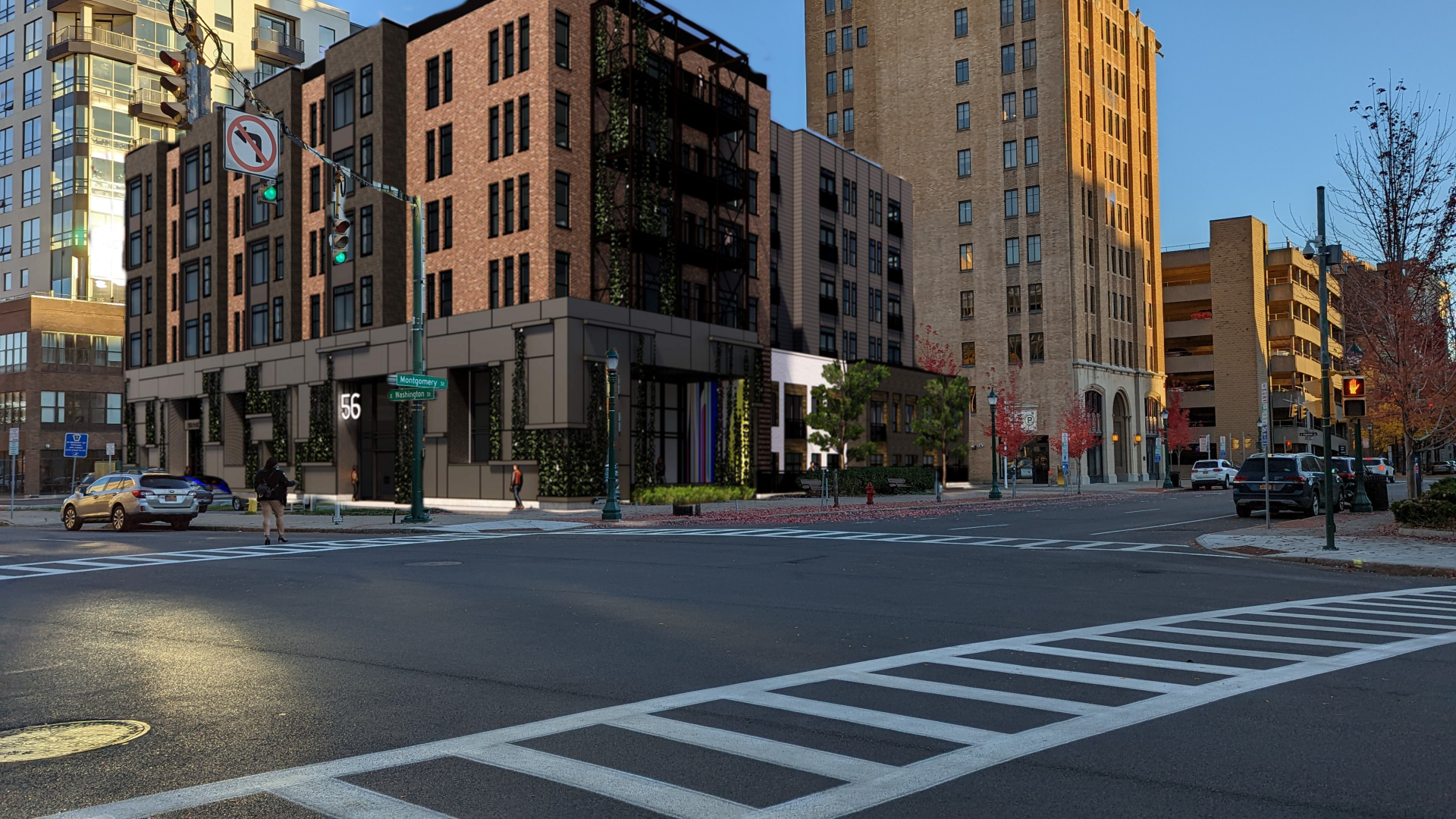
While Downtown has several large parking garages, surface lots still account for a large share of parking for residents and employees alike. Its time for us to rethink that. Most able bodied adults can walk straight across Downtown Syracuse in 10-12 minutes, meaning anywhere is a fairly close walk. The City should look to build a couple new garages, or a cheaper vertical lot that is commonplace in New York City, to begin freeing up development space. As mentioned in Intersections Part Two, the two parking lots across the street from City Hall are prime locations for new development. City Hall Commons, just a block away, is likely to go up for sale soon, with a residential conversion likely as it sits squarely within Hanover Square, one of the more desirable neighborhoods Downtown.
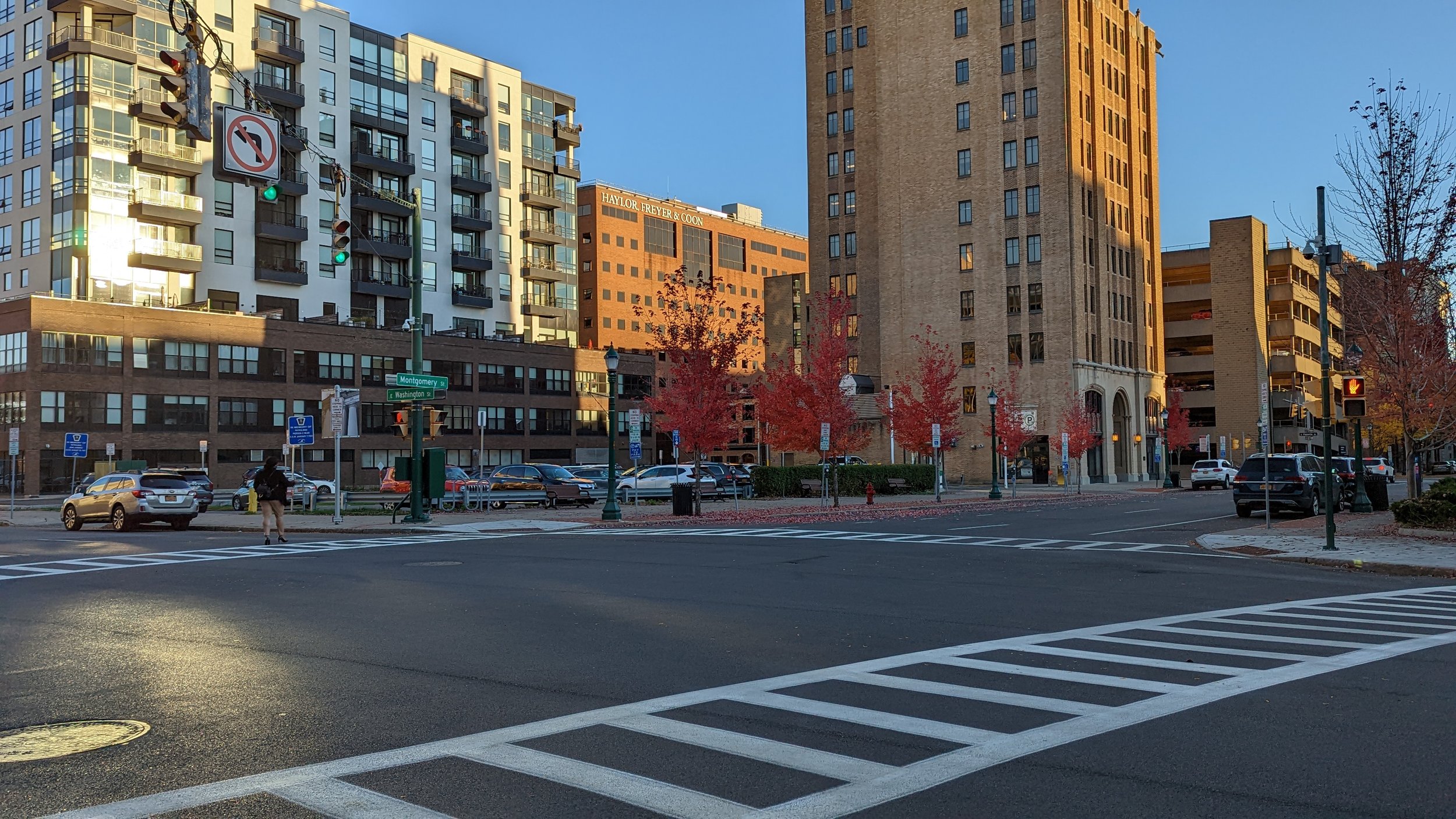
City Hall parking lot.jpeg
City Hall parking lot After.png
City Hall parking lot.jpeg City Hall parking lot After.png

As Downtown is one of the places where we can really add density, not just 4 and 5 story buildings, but up to 8 and 10 stories each across the neighborhood with retail and office mixed in. While Downtown apartments have been continually increasing in price, we should be looking to the recent examples of The Smith and Corbett Corner for ways to approach creating more affordable housing in an increasingly dynamic neighborhood.

In addition to these opportunities, the BluePrint 15 project, which is working to update the public housing neighborhood just south of Downtown. This project aims to keep residents within the neighborhood while improving their access to services and amenities, as well as create more of a mixed-income neighborhood. This is an ongoing project that should be a model for all of the future developments within the City.

Inner Harbor / The Ballpark

The Inner Harbor and the area around NBT Bank Stadium have continually interested me in terms of development. Both sites sit close to Downtown, border the Regional Market, and have easy access to major transportation infrastructure, including the Regional Transit Center, 

Cor Development has been dragging its feet in pursuing their build out plans for the inner Harbor up to this point, but any fear of lack of demand should go out the window now. Their initial site plans call for over 400 residential units, mixed between apartments and townhouses, across the site.  This likely results in homes for over 600-700 people. If built out, with the large parking lots in the designs, the residential area would reach a density of roughly 18,000 people per sq mile. But, as I will discuss in Part Two, those parking lots are larger than what will be needed if we truly commit to a transit oriented development style, with the right transit in place. Cutting those parking lots in half and adding additional townhouses would provide additional home ownership opportunities, at more manageable prices, while adding to the walkability of the area.

Should this prove successful, the two large lots across Solar St, which are roughly the same size as the proposed residential development, will almost certainly spark further development at similar levels of density.

Now, over to the ballpark. I’ve continually advocated for the redevelopment of the large parking lot that surrounds the stadium, arguing that it would help create a deeper tie to the team in the community, encourage additional uses of the stadium beyond baseball, and create an opportunity for people, like me, to live near the ballpark. As someone who used to live just three blocks away from Yankee Stadium, its an experience many people, especially baseball fans, would relish. Today, there is nothing quite like that. Even the neighbors closest to the stadium must first walk through a sea of asphalt and cars to get to the ballpark, hardly an inviting entrance.

Syracuse Developmental Center

Earlier this year (2022), the City of Syracuse signed an agreement with the Albanese Organization to redevelop the former Syracuse Developmental Center into a mixed-use neighborhood. Some concerns were raised about the number of housing units that may be built in the development, with some preferring a final build out closer to 300 instead of the initial 600 envisioned. If we’re looking to provide housing at all income levels, pushing for closer to 600 homes, with an emphasis on townhouses and apartments, would make that more feasible  and more attractive for the developer. 

Sky Top

Syracuse University’s long term vision is to consolidate students and academics onto its Main Campus, leaving behind its sprawling South Campus, which is currently home to over 2,400 students on roughly 150 acres. While the University probably has plans to maintain the land for potential future athletic facility development of some sort, it should, instead, open up the land for redevelopment. The sheer amount of land is something that is hard to come by in a well developed urban center, with close proximity to many of the region’s largest employers. 

The existing apartment complex is very suburban in nature; small townhouses surrounded by parking and wide open spaces, similar to those found along many major arterials throughout the County. While these buildings could be repurposed as is, the current development style is not ideal for transit access and walkability. Adding commercial nodes and further infill development would help create a more self-sufficient neighborhood oriented towards transit and active transportation options.

Near East Side

One of the places already experiencing a building boom is the E Genesee St corridor as student housing continues to pop up. This general trend should be encouraged, as it frees up many of the homes in the University Neighborhood for families to move back into. But we should also look to create a better mix of buildings and housing types. Currently the trend is to build large, monolithic buildings, such as the Theory or the upcoming Laurel. These buildings do offer some street level activity along their fronts, but their sides are dominated by parking structures which deaden the block as you walk by. Some additional large scale development may be warranted in these areas, but we should look behind the Theory for a better approach.

View fullsize The Theory
The Theory
View fullsize Uncommon Apartments
Uncommon Apartments

Uncommon Apartments, which faces E Fayette St, renovated the former Sylvester building, built in the late 1800s, and expanded it. The building is around a quarter of the size of the Theory, yet its commercial spaces have already been leased and the building generates significantly more activity on the street level. We should look for ways to encourage buildings of this scale throughout the area, especially as more development opportunities appear once the I-81 project is completed.

Other Neighborhood Development

While the areas identified above have significant space for development opportunities, many other neighborhoods still provide opportunities for denser levels of development. Part of this needs to be encouraged through zoning, and specifically the elimination of single-family zoning citywide. There is no reason two-family homes should not be allowed in any neighborhood. But we also need to encourage different housing types.

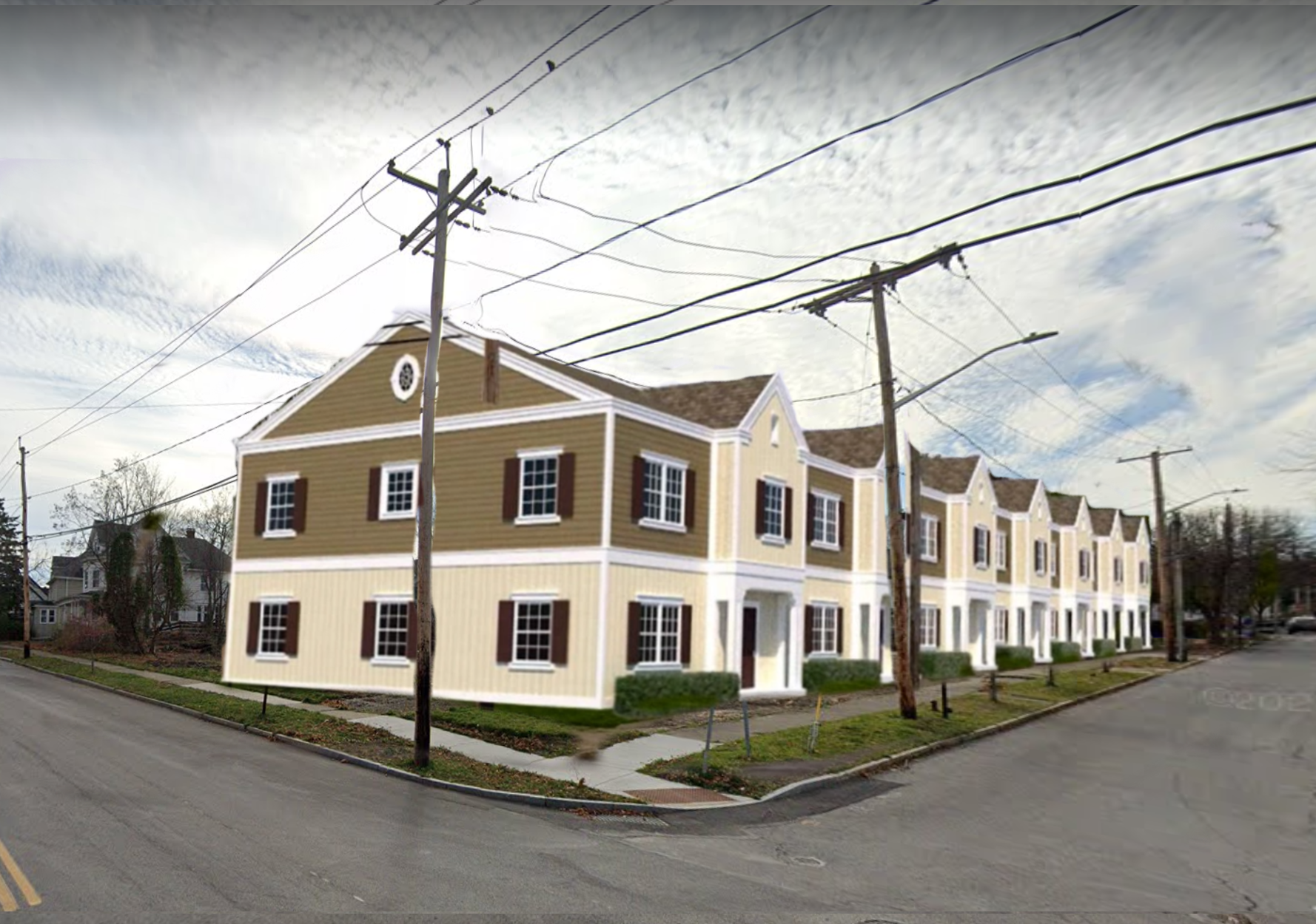
One of the projects that has excited me in recent years was the announcement of new townhouses in the Tipp Hill neighborhood. The project would take the lot formerly occupied by a flower shop and turn it into seven townhouses that would be sold to own. Sadly, this project has hit roadblocks in recent years, but there’s still a positive momentum. Larger lots like this should be eyed for townhouse development in every neighborhood. Adding a few extra households through a few townhouses per block would go a long way to our density goals while increasing homeownership opportunities.
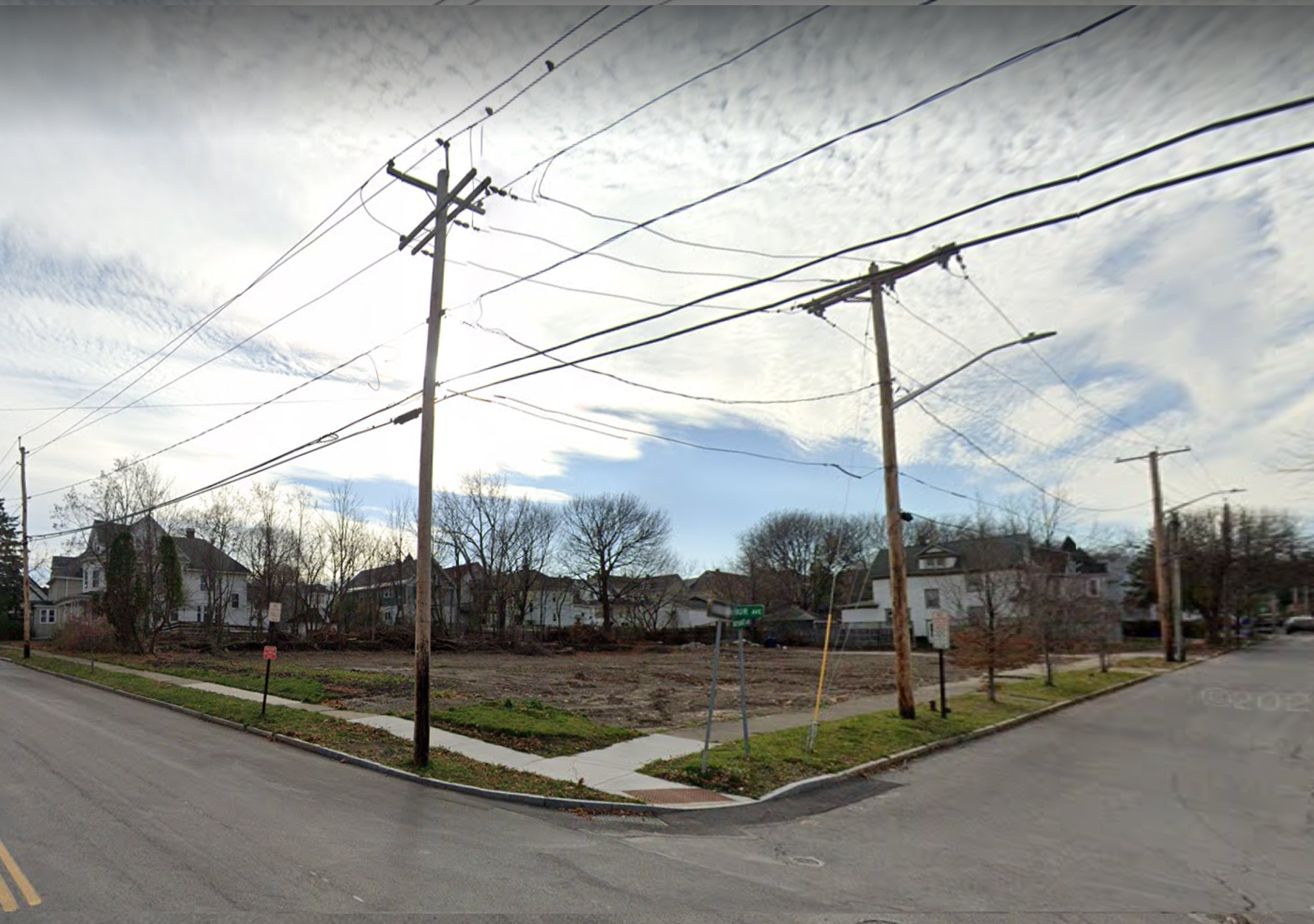
Tipp Hill Before.png
Tipp Hill After.png
Tipp Hill Before.png Tipp Hill After.png

Inner Ring Suburbs

The City of Syracuse is not the only municipality ripe for infill development. Many of the inner ring suburbs, those closest to the central city that were typically developed early on and still maintain some transit oriented features, have stagnated in population and have commercial spaces that are low hanging fruit for redevelopment. The County’s housing presentation did not emphasize development within these towns, favoring many of the outer suburbs, like Clay and Cicero, instead. This is a missed opportunity and we should make sure we focus development in these areas first.

Mattydale

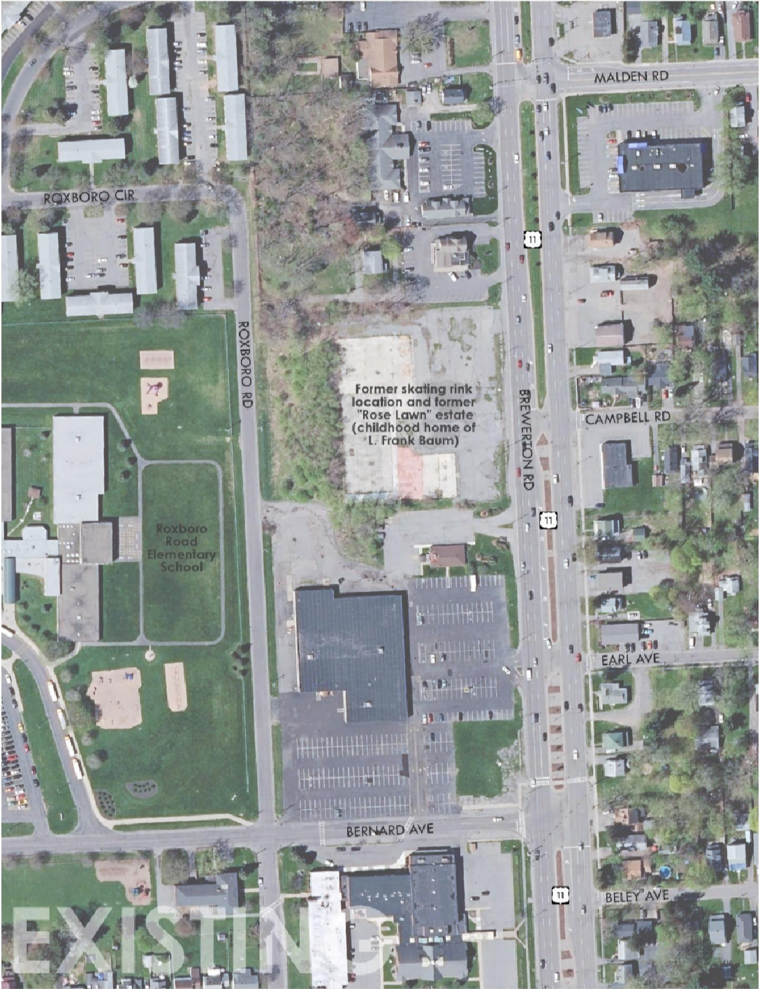
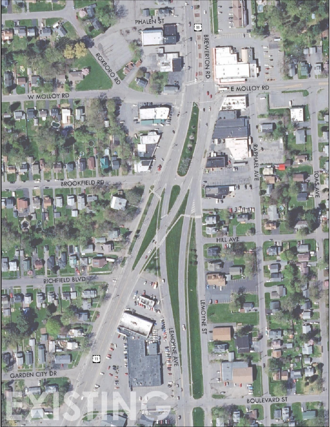
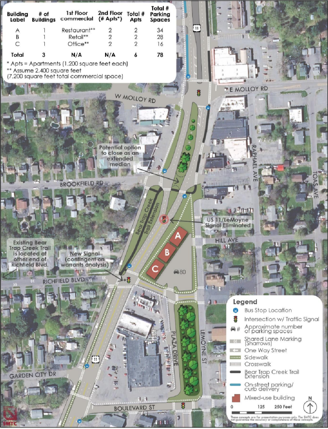
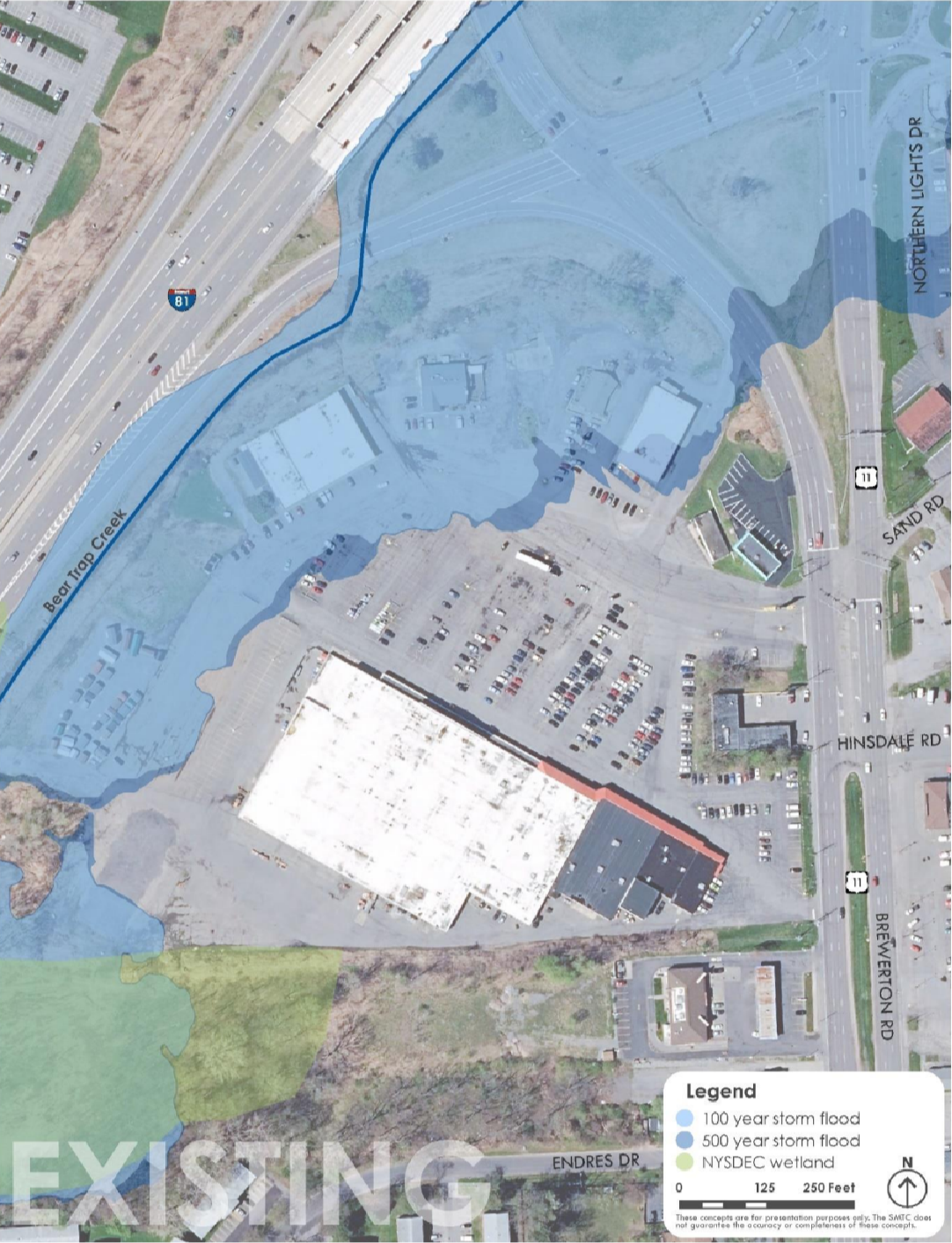
The hamlet of Mattydale is one of the prime locations for future development, especially in terms of more affordable and accessible housing. The hamlet sits just north of the City with access to nearby highways and opportunities for expanded bus access. Yet, as suburbanization has expanded further out from the City, the retail plazas within Mattydale have slowly been vacated, with some just outright demolished. As a result, the already overbuilt Route 11 has become even more of a mini highway bypassing the neighborhoods.
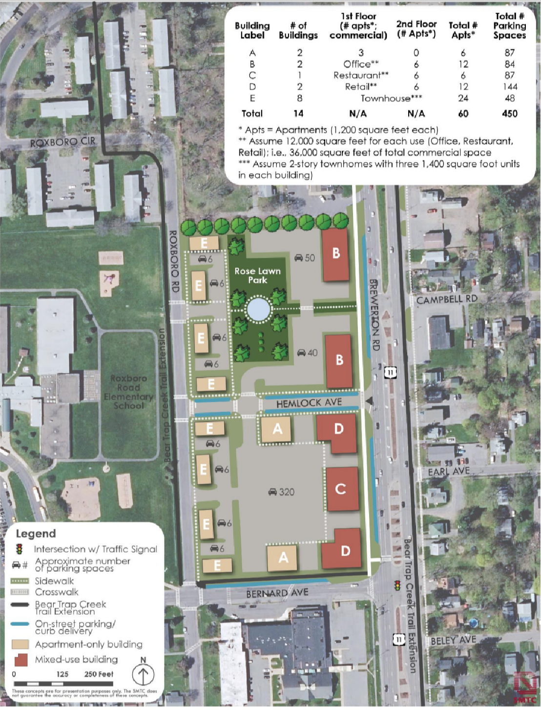
Screen Shot 2022-10-26 at 8.27.39 PM.png
Screen Shot 2022-10-26 at 8.27.57 PM.png
Screen Shot 2022-10-26 at 8.28.12 PM.png
Screen Shot 2022-10-26 at 8.28.27 PM.png
Screen Shot 2022-10-26 at 8.28.41 PM.png
Screen Shot 2022-10-26 at 8.28.59 PM.png
Screen Shot 2022-10-26 at 8.27.39 PM.png Screen Shot 2022-10-26 at 8.27.57 PM.png Screen Shot 2022-10-26 at 8.28.12 PM.png Screen Shot 2022-10-26 at 8.28.27 PM.png Screen Shot 2022-10-26 at 8.28.41 PM.png Screen Shot 2022-10-26 at 8.28.59 PM.png

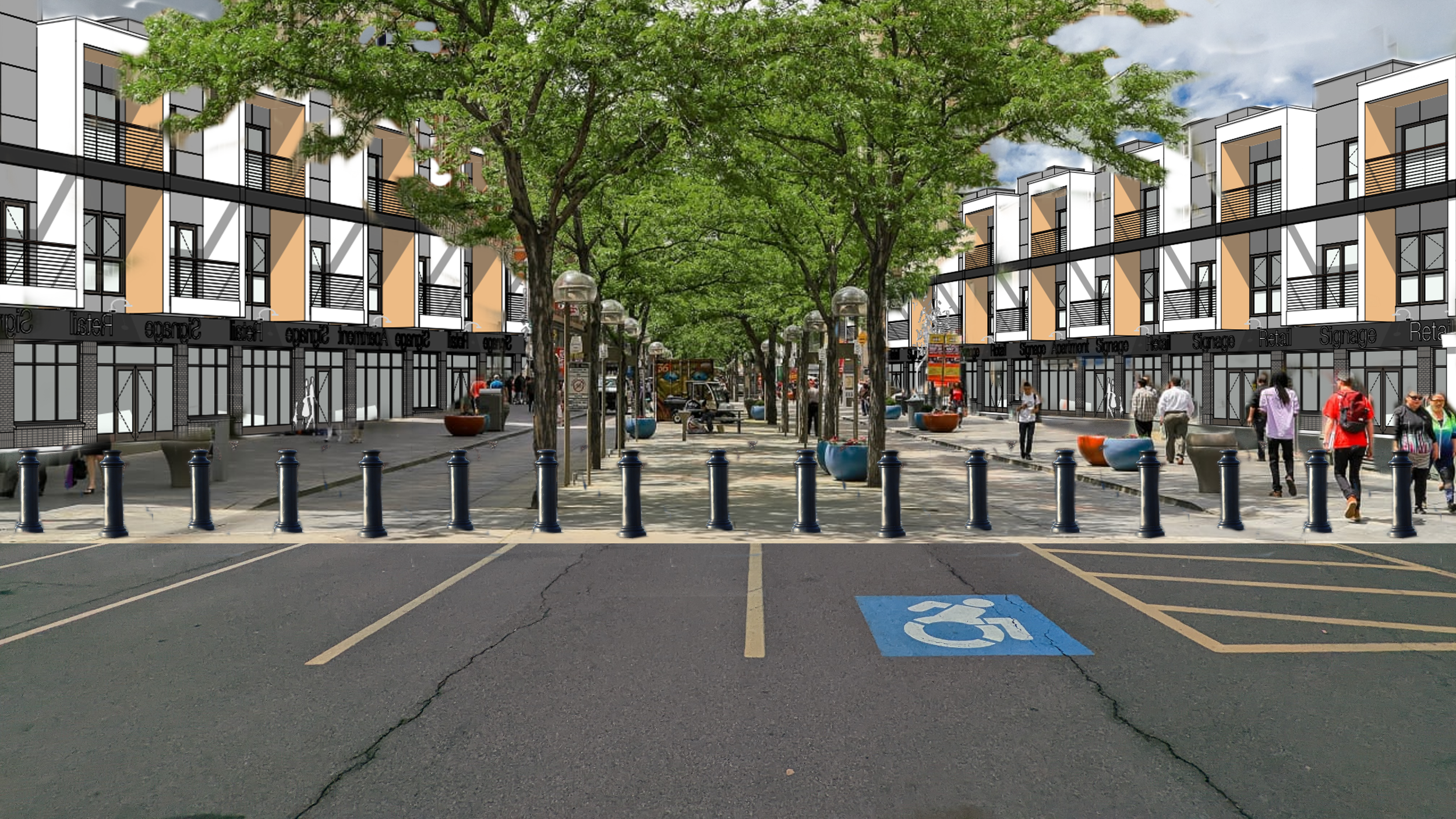
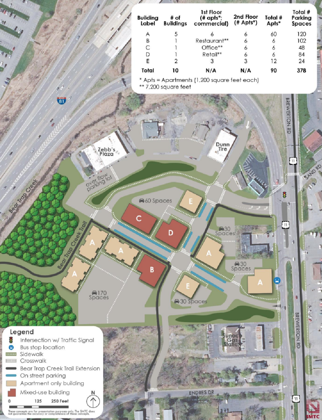
In 2022, the Syracuse Metropolitan Transportation Council (SMTC) completed a plan that looked at Route 11 to evaluate opportunities for infill development and right-sizing the mega stroad that splits the hamlet in half (which will be revisited in the transportation post). The plan calls for two story apartment and mixed-use buildings at three different sites that are either currently empty or vastly underutilized, resulting in roughly 150 additional housing units. This would account for the vast majority of the 200 additional units the County believes the Town of Salina can build out. Even then, this plan is conservative due to the zoning restrictions in place. The large sea of parking required by the current zoning code reduces the positive impacts this revelopment can bring. A simple correction would be to keep the parking generally as recommended, but add one to two more floors to each proposed building, increasing the number of residents within a walkable distance to the amenities already present within the hamlet and increasing the likelihood of more being built.

Westvale Plaza

Just west of the City line, Westvale Plaza is a perfect example of a mid-century commercial center. Fairly compact in size, compared to its more modern counterparts, and fronted by a large, expansive parking lot. In 2019, the Town of Geddes and Village of Salina published a joint comprehensive plan that envisioned this commercial node as a mixed-use development that filled in portions of its parking lots with further commercial space and revamped the existing plazas as mixed-use buildings. 

Concept site plan from the Town of Geddes and Village of Solvay Comprehensive Plan

While the Village of Geddes already has a more traditional Main St north of this area, along Milton Ave, the Westvale Plaza area is centrally located to fairly large population centers and is located along an important bus corridor. No exact plans or redevelopment options were explored within the comp plan, but the current plaza’s footprint (parking included), of roughly 14 acres, could easily handle 200 - 300 units of housing, which is far more than what the County currently envisions for the Town of Geddes (100 units). Using the County’s average renter occupancy of ~2 people per unit, at the high end (600 people housed) that would result in a density of around 27,000 people per sq mile. While this is high, consider that the Theory (the apartment building near SU campus mentioned previously) houses over 600 residents on less than 2 acres.
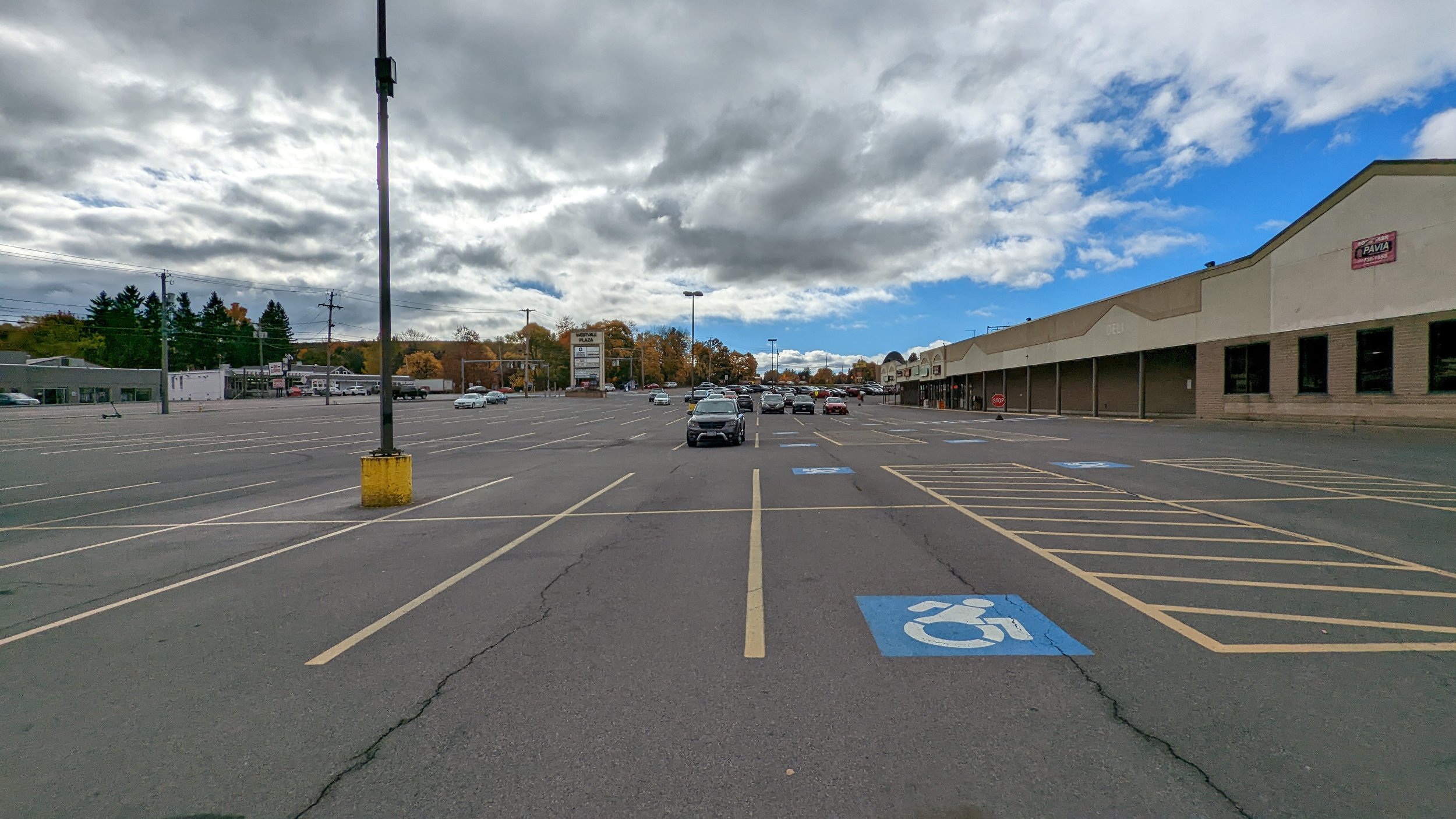
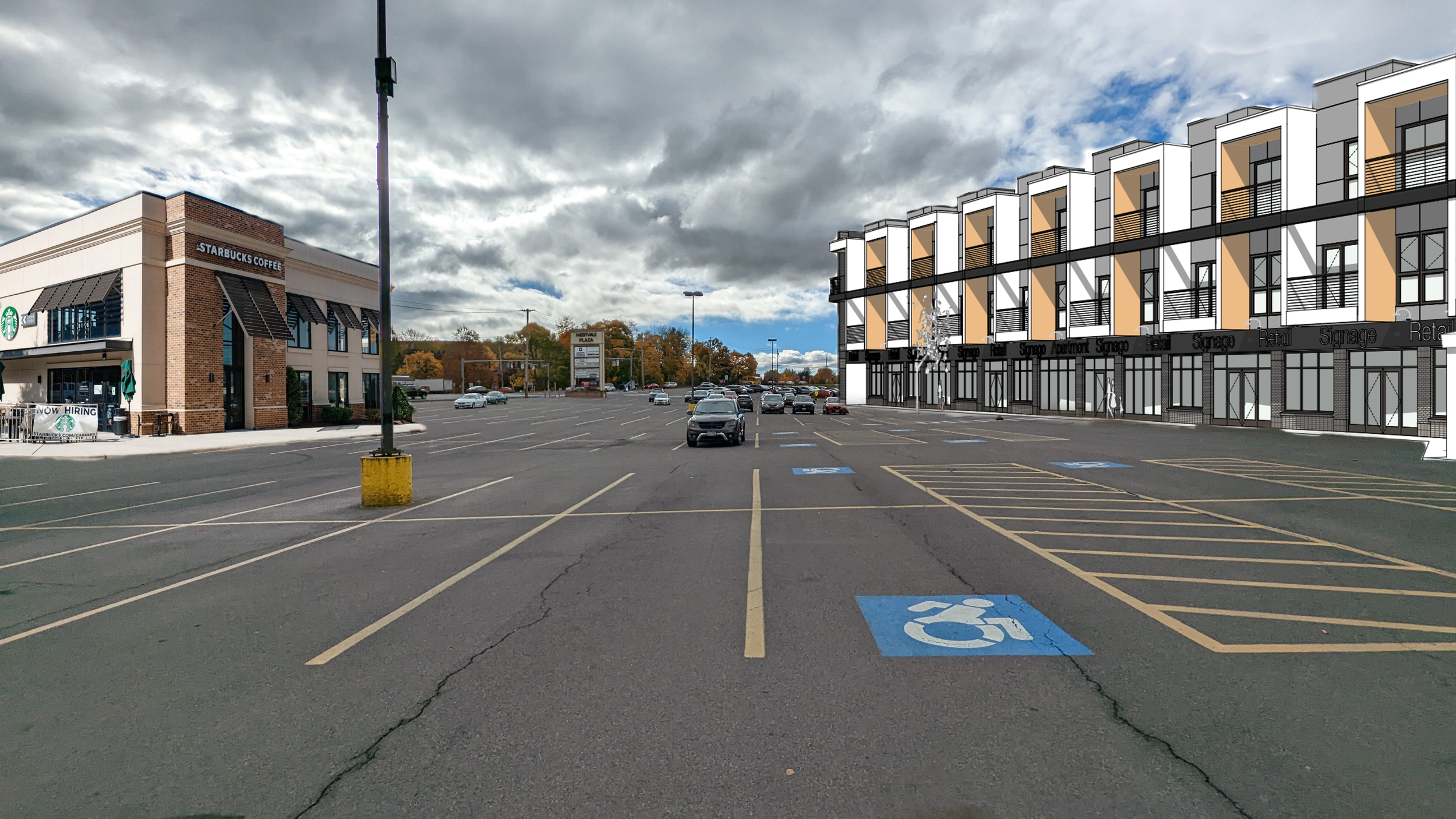
Westvale Plaza.jpeg
Westvale Plaza light.png
Westvale Plaza. Afterpng.png
Westvale Plaza.jpeg Westvale Plaza light.png Westvale Plaza. Afterpng.png

A less intensive redevelopment, while maintaining the same number of new units, would see the nearby Geddes Plaza and other commercial properties redeveloped as well.

Shoppingtown Mall (District East)

In the summer of 2021, a long awaited redevelopment of Shoppingtown Mall was announced: a mixed-use development with over 500 units of housing known as District East. I have few notes on this proposal, based on what is known publicly at this time, as its location and intent align perfectly with what we should be looking for in terms of development opportunities. It is located along a well used, and easily improved, transit corridor; the Empire State Trail (EST) runs directly behind the property, creating easy access through active modes of transportation; and the development instantly becomes a new downtown for the Town of Dewitt.

View fullsize Rendering of District East
Rendering of District East
View fullsize Site plan for District East
Site plan for District East

What should be encouraged is the further redevelopment of commercial properties along Erie Blvd E. Marshall’s Plaza, nextdoor to Shoppingtown Mall, has continually seen infill commercial development, reducing its parking lots in favor of more commercial activity. Other plazas, which have been less successful recently, should look to do the same, but add a mix of housing and office space. The Erie Canal, which was later replaced by Erie Blvd, was once the economic engine of the region. With a well planned redevelopment along the corridor, Erie Blvd can once again become an economic engine instead of, as the New York Times described it, “a rundown stretch of strip malls and muffler shops.”

Outer Suburbs

As mentioned above, the County is emphasizing development of single-family homes in the outer suburbs, which are the most difficult places to serve with transit and provide services. While I believe these areas should not be the focus of development, their close proximity to the White Pines Commerce Park make them attractive to many. So let’s look at places that can handle infill development and lend themselves to a more transit oriented development style. Many places will still emphasize single-family homes, but we should ensure they’re built in a denser fashion than what current local zoning laws permit.

Luckily, many good plans exist for these areas and we can only hope and encourage that they be developed accordingly. 

Rt 11 Corridor

In 2020, the SMTC worked with the Town of Cicero on a plan for the Route 11 corridor through the town. This plan identified infill development opportunities of over 1,600 units of housing, primarily apartments and townhouses, directly behind current commercial developments along Route 11. The aim of this plan was to identify opportunities to create housing that would encourage residents to walk, bike, or take transit to already existing nearby commercial centers. 

What was not planned for during this study, was the study area to be within a very short distance of the new Micron development. As such, this development proposal, nearly twice as many units as envisioned by the County for the Town of Cicero, should be thoroughly considered as it has already been vetted by community members. A developer and more detailed plans would be needed, but the general concept should be encouraged.

Great Northern Mall

North of Syracuse, Great Northern Mall has struggled financially for years, especially after the expansion of Destiny USA. In the summer of 2022, a developer announced a plan, similar to that of District East, to redevelop the struggling mall into a mixed-use center with roughly 500 housing units. While this location is less ideal than Shoppingtown, its close proximity to the Micron site makes it a perfect western anchor to any additional bus service added to the corridor, especially if the Route 11 developments noted above are followed through.

Brewerton

The final location I’m looking to emphasize in terms of housing development is also home to an existing proposal, but this one is unique. Onondaga County is a fairly landlocked county, even with access to several lakefronts. As a result, any development along the available lakefronts that offer up multi-family housing options is worth pursuing. The same developer that is looking to redevelop Great Northern Mall has staked out a plan along Oneida Lake for a mixed-use community, with an emphasis on multi-family housing. Currently, the plan also calls for a large number of single-family homes, but the plan would be enhanced if it switched out detached homes for townhouses. This would allow the hamlet of Brewerton to become a true northern anchor to any public transit enhancements made to accommodate the Micron development. As the hamlet sits on the northern reaches of Route 11, the increased development along this important route will lend itself to more walkable and transit oriented development (which will be discussed further in the next blog).

View fullsize Rendering of proposed Brewerton development
Rendering of proposed Brewerton development
View fullsize Site plan of proposed Brewerton development
Site plan of proposed Brewerton development

Doing Housing Right

Each of the neighborhoods identified above are prime locations for expanded housing and denser development, but we need to be open to gentle increases in density throughout the county. This is the first time in 50+ years that Onondaga County must confront a dramatic increase in population and we can’t afford to let suburban sprawl take over as it has in recent years. Construction on Micron will begin in 2023-2024, and the I-81 project will begin by the end of this year. We must act quickly to alter our zoning codes and create a more unified housing policy to encourage these dense development opportunities. New York State should also follow California’s lead on allowing accessory dwelling units and two-, three-, and four-family homes in all neighborhoods. We also need policies tied to transportation infrastructure that will make the dense developments discussed above possible. And this tees up our next discussion: with all of this new housing development, what does this mean for our transportation networks? And what can we do to make sure public transit and active transportation options play a major role in our region’s future?

In Urban Planning, Housing
Comment

Color My World: Why Cities Should Embrace the Colorful

September 30, 2022

The City of Syracuse has been on a mural painting craze in 2022, with a City sponsored program (City as Canvas) funding murals in eight different neighborhoods and local businesses funding their own artworks. This continues a trend of murals popping up in cities across the country. As I’ve traveled through various Rust Belt cities over the past year, murals have been an increasingly popular way to liven up spaces around vacant lots or parking areas next to recently renovated buildings. They bring color and character to spaces that once sat empty for decades, and I am all about it. But, we shouldn’t just think of murals when we look for ways to brighten up our cities. We should be embracing color in everything we do - on our buildings, our roadways, our parks. Let’s take a look at different ways cities have embraced color and point out opportunities across Syracuse where color can be added to our everyday lives.

Murals

Murals have been part of the human experience for thousands of years. Nearly every great civilization has used murals to showcase different aspects of their culture - whether its the power of the gods, the value of the state, or key historical events. 

Cities across the United States have embraced murals over the last several decades. Philadelphia, like many other older industrial cities, has seen murals as a form of reinvestment in each of its neighborhoods. Over the past 35 years, over 4,000 murals have been painted across the city, making it one of the largest collections of murals in the world. Closer to home, Buffalo, NY’s Albright Knox Art Gallery has been funding public murals across the Queen City since 2014. While some of the most powerful murals cover the entirety of a building’s facade, they can also be small, hidden gems meant to engage people as they walk around their neighborhood. This mixture is what makes murals so engaging. They surprise viewers and keep the urban environment exciting in a positive way. 

Syracuse has plenty of examples of murals in all shapes and sizes. A massive mural depicting local basketball legends was just recently completed in Downtown Syracuse, created by a world famous muralist. At the same time, the City as Canvas program has looked to borrow a page out of the New Deal’s Works Progress Administration (WPA) by putting local artists to work on murals in each neighborhood. This is a model the City should continue to use beyond the initial eight murals. Partnering with local businesses and institutions, the City should create a fund to paint five to ten new murals each year, depending on the sizes proposed, and hire local artists to get the work done. A prime location for a series of murals would be the elevated train tracks that cut through the City, both through Armory Square and across the Southside. While coordinating with the railroad to get the effort kickstarted may be difficult, the color and life that the project would bring is worth the effort. 

View fullsize Community Garden Mural - NYC
Community Garden Mural - NYC
View fullsize Parking Lot Mural - NYC
Parking Lot Mural - NYC
View fullsize Syracuse Elevated Freight Rail
Syracuse Elevated Freight Rail
View fullsize The Atrium
The Atrium

A personal wish of mine is to see the Atrium, which sits on the south end of Clinton Square, covered in murals. It is currently the ugliest building in Downtown Syracuse, but covering it in murals would elevate it to become one of the jewels of our city. Its blank walls, flush windows, and fairly smooth brick exterior could provide an excellent canvas.

But we should remember that murals are not the only way to bring color to our buildings.

Colorful Buildings

View fullsize Philadelphia Rowhouses
Philadelphia Rowhouses
View fullsize DC Rowhouses
DC Rowhouses

One thing you’ll notice the more you watch HGTV is the feeling that every house ends up being one of three colors: white, grey, or tan. These are the same colors most homeowners associations (HOAs) will allow. There might be some color added on a door or a darker trim around the windows, but we are increasingly seeing a homogenous look to our neighborhoods.

Now having some homogeneity in our built environment can be a good thing. Row houses, brownstones, Victorian homes are all often found in duplicates or groups of similar structures. The repetition can be part of the charm of a neighborhood, such as Brownstone Brooklyn. But if we start to take a wider look around the world, we start to see color playing a much larger role in these structurally homogenous neighborhoods, making Brownstone Brooklyn’s brown variations an outlier. Cities across the world, including many older American cities, have embraced color in their neighborhoods, resulting in bright, friendly neighborhoods. Philadelphia and Washington, D.C., as seen above, both showcase homogenous neighborhoods that embrace bright colors to add character and warmth.

View fullsize Sister Houses
Sister Houses
View fullsize The Hudson Building
The Hudson Building
View fullsize Victorian on James St
Victorian on James St
View fullsize Pond St Businesses
Pond St Businesses

Syracuse has some examples of this, with the most prominent being the five Sister Houses in the Park Ave neighborhood. These beautiful old Victorian homes are identical except for their color palettes. Back in Downtown Syracuse, the Hudson Building has also worked to differentiate itself through color, bringing a bold, forest green to a streetwall filled with red brick. Color doesn’t always have to be bright, but going beyond the traditional color palettes help invigorate a space. We should encourage building developers to utilize materials that can be painted easily and updated to reflect the personalities of the tenants inside. Keep the designs simple and infuse them with life through paint.

Paint is not the only way to bring color to a building. Many taller buildings in downtown business districts have embraced light displays to enhance their skylines. These lights are often coordinated with one another to celebrate holidays, sporting events, or just bring awareness to different causes. While these light shows are beautiful to behold, we must get better about using the lights properly to not interfere with bird migrations and other natural occurrences. 

Colorful Streets

We may not think of our streets as a place for any colors beyond black, yellow, and white, but they are public spaces and public spaces should embrace color wherever they can. Some may be more functional (bus and bike lanes) while others more decorative (street murals and painted plazas), but they all function to bring color and life to our cities.

When thinking of the more functional colorful elements, bus and bike lanes are often the first to come to mind. Often referred to as Elmo and Kermit due to their bright red and green colors, these lanes serve the important function of providing spaces for residents to get around outside of a private vehicle, giving them priority where possible. Also, as an avid Muppets / Sesame Street fan, I appreciate the references that bring a bit of childlike wonder to infrastructure. These are essential tools for every city, and they bring the added benefit of color with them. When you look at streets filled with bus and bike lanes, the visual appeal and interest of the space increases substantially.

View fullsize Brick Patterned Crosswalks and Colorful Barriers
Brick Patterned Crosswalks and Colorful Barriers
View fullsize S Salina St Bike Lanes
S Salina St Bike Lanes
View fullsize Seattle Painted Curb Extensions
Seattle Painted Curb Extensions
View fullsize Rochester Piano Crosswalk
Rochester Piano Crosswalk

Other functional colorful elements tend to be focused around intersections. Using brick or stone pavers for complete intersections, or specifically in crosswalks. Painted crosswalks (which is still frowned upon by federal agencies and the MUTCD) have been embraced by cities across the country. Rochester, NY celebrated the Eastman School of Music by painting a piano style crosswalk just outside its doors.

Other cities have embraced paint as a way to extend the pedestrian realm, through painted plazas and curb extensions. Seattle, WA has an extensive network of painted curb extensions that embrace colorful designs to draw the attention of drivers. Syracuse will be embracing the idea of a painted plaza in the near future right in front of City Hall, after it awarded the design to another local artist.

This is not the first time Syracuse has painted its streets. In 2017, Syracuse hosted the World Canals Conference. It celebrated by painting a canal themed mural outside of the Erie Canal Museum, harkening back to the waterways that built the City. These murals were short lived due to the wear and tear of traffic, but we should look for streets to pedestrianize and fill with color that will last without cars driving over them.

Natural Colors

View fullsize Burnet Park in Fall
Burnet Park in Fall
View fullsize Basilica of the Sacred Heart of Jesus
Basilica of the Sacred Heart of Jesus

Up until now the main focus has been on how to bring color to our man made structures, but we should never forget to embrace the color and life that nature can bring into a community. 

At the moment, we’re entering into the heart of autumn, my personal favorite season. Oranges, reds, and yellows burst from the trees across the region, making for a beautiful sight. Different trees showcase different colors during this time and the mix of trees not only creates a more vibrant scene, but also a healthier one for the trees as they help reduce the spread of tree borne diseases.

Community gardens, such as the Syracuse Rose Garden, are another perfect example of natural colors bringing people together in a space of beauty. The groups that help upkeep these spaces help build community through the action of gardening and the result of a beautiful garden to be admired. 

Many of these spaces take the addition of color to an extra level through the inclusion of art. The Lipe Art Park, while light on trees and flowers, embraces the use of art through a linear park. The Onondaga Creekwalk is beginning to explore similar opportunities, especially under the overpasses between Downtown and Franklin Square. Should a multi-use path eventually connect these two spaces, as is being explored in an ongoing study, the City of Syracuse will soon provide its residents with an active commuting corridor surrounded by art and color that would be a national example. 

These are all just some examples of how we can embrace color and art in our urban spaces, but we need to provide opportunities for communities to use these tools to fit their own visions. Get rid of the HOAs and embrace colors that showcase the personality of your neighborhoods and your City as a whole.

In Civic Pride, Housing, Walkability
1 Comment
IMG_20200816_134103.jpg

To Fight the Climate Crisis We Need: To Start Right Now

August 25, 2020

For the summer of 2020 I will be releasing a series of articles reflecting on some of the things cities, and urban planners specifically, can be advocating and planning for to help in our fight against the climate crisis. These pieces will reflect on our transportation networks, the need for urban living, and protecting our natural resources while bringing them into the city. While these are not comprehensive of everything that needs to be done to turn the tide of this crisis, they will provide a different vision of what our world could be like if we commit to a different form of development.


At times the climate crisis feels too large to tackle with too many pieces that need to be addressed all at once. Many will point to the role of multinational corporations and their outsized impact on the environment, noting that 100 companies have been found to be responsible for 71% of emissions since 1988. They believe that these corporations should be forced to change while changing very little about their own behavior. Yes, those corporations need to be forced to change, but since the biggest culprits are gas giants like Exon and BP, our behavior impacts their decision making. I’ve spent this summer going through big picture ideas of how we can reshape our cities to help fight this crisis, but for the last piece in this series I want to focus on a few specific things we can do right now that will get us on our way.

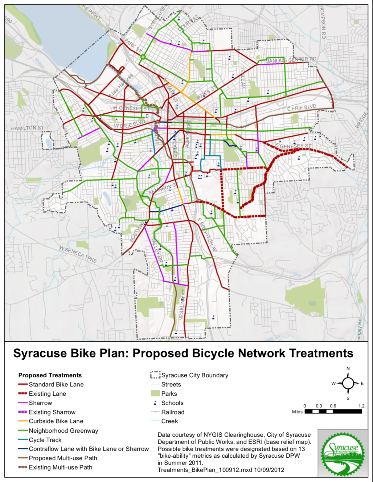
Syracuse Bike Plan
Syracuse Bike Plan
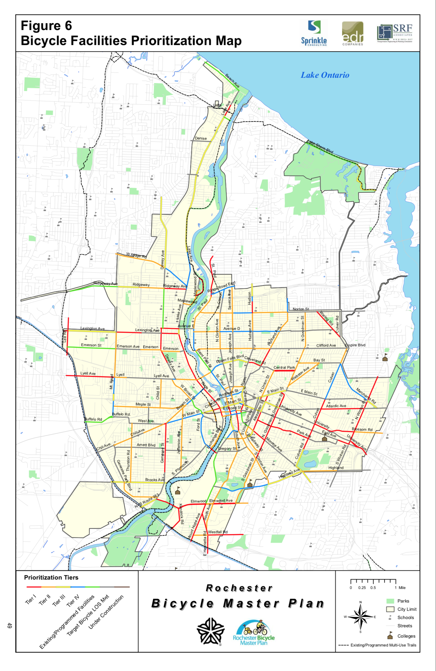
Rochester Bike Master Plan
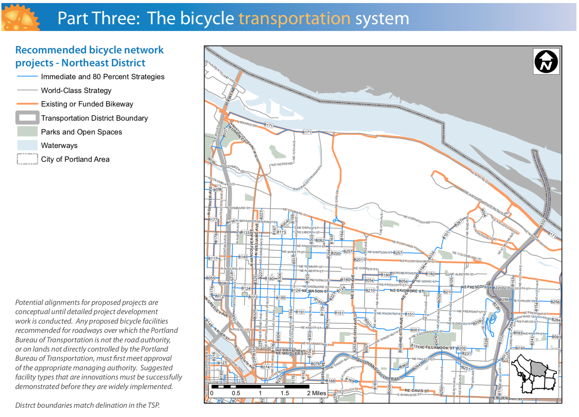
Portland Bike Plan 2030
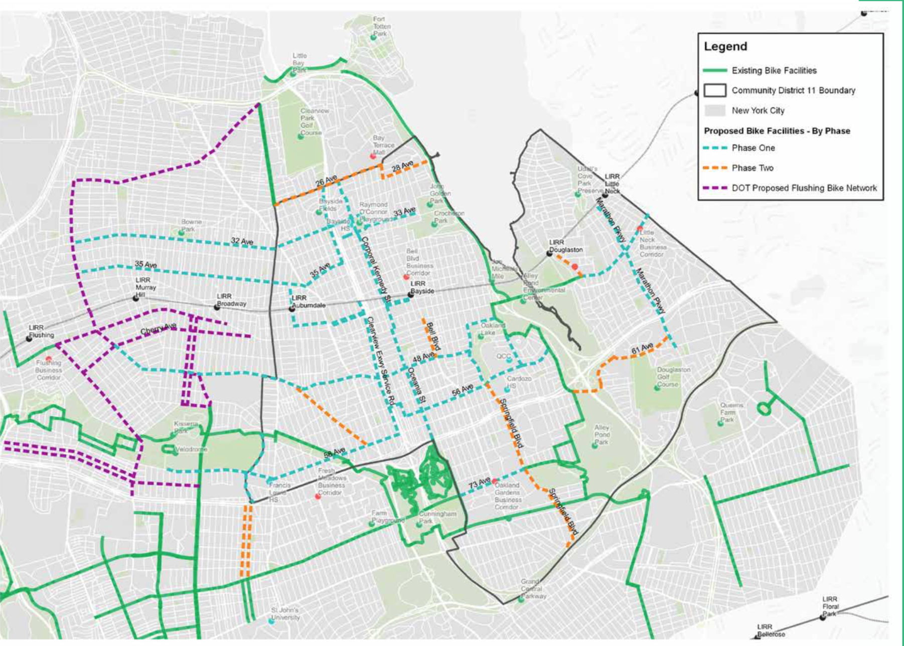
Hunter College Bike Plan for QCD11

Implement Your City’s Bike Plan

Every city I have lived in has some form of vision plan for an extensive bike network, yet very few have made significant progress implementing them. The planning has been done, the desired routes have been identified, yet we continue to wait. Some are waiting for funding to add protected bike lanes and streetscape elements along the routes, while others are stifled by backlash from communities worried about parking. But now is the time to jump start those plans.

Protected lane on Northern Boulevard in Queens, New York using a jersey barrier.

Protected lanes can often be done in low cost ways, such as using flex posts or parking blocks. Some places have even opted for jersey barriers which, while not visually appealing, offer high levels of protection for people on bikes. You can also make use of parking protected lanes that only require slightly more paint than a standard lane. Parking protected lanes often come with controversy due to drivers being uncomfortable with the new parking design, but cities shouldn’t be quick to revert back at the first sign of pushback. People can adapt and learn.

We should also remember that most lanes that cities have proposed are just standard lanes, simply requiring paint on the ground. Cities should be looking at their bike network plans every time a street is repaved, putting in their planned lanes as they go along. Even if these lanes are not fully connected initially, they’ll help build out the network faster and encourage their use.

Begin a Bus Network Redesign

Buses remain the backbone of our public transit systems, carrying the vast majority of transit riders in the country. They are also the most versatile transit mode, allowing them to adapt in a short period of time.Yet, as discussed in the earlier piece on public transit, few have significantly changed their networks to reflect the current geography of the communities they serve. This must change in order for these services to meet the needs of their current riders while attracting new riders, which is vital as we look to get more people out of their cars.

While complete redesigns can take several years, the process is much faster and cheaper and can be just as, if not more, effective than building out a rail network. New York, for example, has been working through its redesign process over the last few years, borough by borough, and has begun implementing some of these changes already. Smaller systems should be able to make these changes even faster and should start the groundwork now.

Consider Your Impact When Deciding Where to Live

In the previous piece I dug into the issues with single-family only zoning and our current suburban development patterns. Many of the changes needed to help fix this system will take time, including revamping zoning in municipalities, incentivizing more affordable housing in different forms, and implementing an urban growth boundary, but for those of us who may be moving sometime soon and have the economic ability, consider where you live and its impact on the environment. Whenever possible look for housing close to your work, perhaps along a transit line or bike network. Consider fixing up an older home purchased from your local land bank, or look for rentals (as we begin to decouple home ownership from wealth building, as it is in most of the world). You don’t need a large home for all of those family gatherings you hope to have, no matter what HGTV tries to sell you. Admit to yourself that most of that space will remain empty 98% of the time and find a more functional/efficient way to use a smaller space instead. While the apartment in the video below may be an extreme, we should be looking for ways to use our spaces in different ways to suit our varying needs.

Buy Small, Efficient Vehicles

Although we need to move quickly towards a future without personal vehicles to make the biggest impact on the climate crisis, many of us still live where cars are needed to different extents. If you are one of the millions of Americans in that situation, the next car you get should never be an SUV or pick-up truck (unless you work in construction). As noted in previous pieces, SUVs and trucks are held to much lower emissions and efficiency standards than sedans, making our overwhelming shift to these vehicles even more dangerous. Some will argue they are more efficient than ever before, but that’s a low bar to clear. 

Others will argue that they need them due to the harsh winters their cities experience. As someone who has lived in Syracuse, NY for most of my life and has driven through Upstate New York through heavy snow and ice, you don’t. Instead you should consider whether it is vital for you to drive that day, if there is another way for you to get to your destination (perhaps the bus in some cases) if the trip is vital, or spend some extra time shoveling out your vehicle as many of your biggest issues come with simply getting out of your parking space. This also ties in with where you live, as the further out you live the less transportation options you tend to have to reach your destinations, making it far more likely for you to need to drive in bad weather.

Kids sitting in front of an SUV illustrating the size of the blind spot the taller hoods create.

Source: ABC 7 WJLA https://wjla.com/features/7-on-your-side/7-on-your-side-children-killed-accidentally-run-over-by-vehicles-with-blind-spots

Still others will argue that they need the bigger vehicle to keep their children safe when driving. While this seems logical, the simple act of you driving that vehicle puts everyone else’s life at risk, including your kids as soon as they are not within the confines of your vehicle. SUVs and trucks have dangerous blind spots, as demonstrated by the image above where every child in front of that car is impossible to see by the driver. SUVs and trucks are also far more likely to kill anyone they strike, regardless of speed, due to the increased height of their hoods. Instead of striking someone at their legs, they hit directly in the chest of most people, if not their heads, causing far more internal damage, often leading to death. If we want people to walk and ride bikes more often, which is needed to truly fight the climate crisis, we need to make sure they are safe while doing so. These increasingly large vehicles put everyone’s life in danger, which has been shown by the sharp increases in pedestrian deaths over the last decade, coinciding with the increased adoption of these vehicles. Part of this is caused by the increased security drivers feel in these vehicles, which results in riskier driving maneuvers and more aggressive driving in general. (Consider picking up a copy of Crash Course by Woodrow Phoenix, which is an excellent illustration of the dangers of our current road networks).

While hybrid vehicles have been shown to have the negative effect of encouraging people to drive more, they are still a better option for most families. For others, opting out of ownership and relying on car share services, such as Via, should be considered, although this is only a true option for those living in cities with a decent level of saturation in this market. 

Make Our Covid Open Streets Permanent and Open More

The last immediate recommendation I have is to simply make some of the changes we’ve made to adapt to our new Covid-19 reality permanent. Cities across the country, of all sizes, closed off streets to traffic to open them for people to walk, bike, and dine out to great success. We shouldn’t turn back now, even in winter. Adding heat lamps and coverings can help extend outdoor dining throughout the winter helping restaurants keep their capacities up while avoiding risky indoor dining options. 

Open streets in New York have helped small businesses reach new customers and keep them alive while encouraging people to explore their neighborhood businesses more than ever before. Rethinking our streets as places for people instead of cars can help shift our relationships with our neighborhoods, helping us stay local and explore places on foot instead of feeling the need to drive. This only works if we expand these programs so that everyone is within walking distance of an open street network. 

Together, each of these actions can have significant impacts on our use of fossil fuels, helping to break the influence of those major corporations that have caused so much damage while improving our quality of life and increasing our sense of community. This isn’t just about saving ourselves and future generations from harm, but also about deciding to invest in a better future, one that is more communal and supportive than the me-centric suburban sprawl we currently endure. 

In Climate Crisis, Transportation, Housing, Urban Planning Tags Climate Crisis
Comment
A combination of single-family and multi-family homes in Syracuse’s Tipp Hill neighborhood.

A combination of single-family and multi-family homes in Syracuse’s Tipp Hill neighborhood.

To Fight the Climate Crisis We Need: A New "Standard" American Home

August 11, 2020

For the summer of 2020 I will be releasing a series of articles reflecting on some of the things cities, and urban planners specifically, can be advocating and planning for to help in our fight against the climate crisis. These pieces will reflect on our transportation networks, the need for urban living, and protecting our natural resources while bringing them into the city. While these are not comprehensive of everything that needs to be done to turn the tide of this crisis, they will provide a different vision of what our world could be like if we commit to a different form of development.


Single-family zoning found itself in the spotlight over the summer as people began to consider its racial origins through redlining practices and federal/local subsidies. Others began to turn a more critical eye towards this suburban ideal in the name of conservative economic practices, noting that the suburban experiment’s highly subsidized nature and over regulated zoning policies should upset anyone who claims to want less government interventions in private property. You can also look to the negative health effects associated with suburban living, primarily from the more sedentary lifestyle commuting requires and the increased stress levels driving produced. All of these arguments are valid and should be considered when evaluating where we choose to live, how our cities/towns choose to regulate private property, and where our tax money is sent. But we must also consider the impact our housing choices have on the environment, and perhaps living in “greener pastures” is actually the least “green” thing you can do. 

View fullsize Single-Family Zoning in NYC
Single-Family Zoning in NYC
View fullsize ReZone Syracuse Map
ReZone Syracuse Map

First, to alleviate the concern that I’m advocating for all single family homes to disappear. Eliminating single-family only zoning would simply allow for two-family, three-family, or even four-family homes to be built in every neighborhood, along with single-family homes. Last year, Minneapolis did just that, with an eye on breaking down racial and economic barriers that have been in place for nearly a century. This has been a crucial piece needed to improve access to affordable homes across the city. Many would be surprised to know that New York City still has large areas zoned for single-family only, even amidst an affordable housing crisis. The City of Syracuse continues to perpetuate the use of single-family only zoning in their ReZone project, as many residents argue about protecting the “character of the neighborhood,” which is a common racial dog whistle. Any concern for “neighborhood character” is moot since many multi-family homes look very similar to their single-family counterparts. 

Now, if we look at single-family zoning, and suburban living as a whole, from an environmental perspective the issues mostly arise from the consumption and destruction of resources. Over the last century the average American home has grown significantly in size (from around 1300 sqft. in 1960 to nearly 2700 sqft. in 2014), and many have taken up larger and larger lots. While large lot size requirements grew out of racial and economic segregationist policies, they have also resulted in pushing people further and further apart. Due to both of these factors, emissions related to travel are significantly higher in suburban areas. A report by Ed Glaeser and Matthew Kahn noted that, when controlling for family size and income, gas consumption per year per family decreases by 106 gallons when population density doubles. To showcase just how different our cities and suburbs are built, consider that Syracuse’s citywide density (5,604 people per sq. mile) is nearly five times as dense as its most populous suburb, Clay (1,216 people per sq. mile). Or, you can look at some of Syracuse’s inner ring suburbs, Geddes and Salina, where Syracuse is nearly three times as densely populated (1,813 and 2,186 people per sq. mile respectively), or more than double the density of the surrounding villages, like Baldwinsville (2,293 people per sq. mile). This emissions calculation doesn’t even take into account those who use transit, walk, or bike to get where they need to go, which would reduce the climate impact of Syracuse even further as its density and proximity to job centers/daily shopping needs allows for these alternative methods to be viable options for many trips.

Source: Bloomberg City Lab

Source: Bloomberg City Lab

Beyond the issues related to commuting, single family homes themselves consume far more energy than multi-family units. The chart above demonstrates the differences in energy consumption between an average suburban home, along with the multiple cars used to connect it to the wider community, and condo units located in urban centers, with fewer cars needed to complete needed trips. Even without factoring in the vehicles, or type of vehicles, the homes themselves consume significantly less energy. One of the main reasons for this difference simply comes down to size. Every year the National Association of Home Builders (NAHB) constructs a dream version of the American home with the aim of setting standards for new home construction. While energy efficiency has been at the forefront of many of the newer homes, they have also grown to grotesque sizes (around 11,000 sq.ft. in 2018). While these homes are not standard by any means, they’re often used to gin up demand for many of the showcased products and styles, and, most importantly, space. This is even as the average family size has dropped by over 30 percent, resulting in fewer people occupying even more space and filling it with unnecessary purchases. You can often see this on display on HGTV with people demanding more space to host parties or have”family get togethers”, which may see that space used a handful of times per year if that, often leading these home buyers further out of the city centers adding significantly to their commutes. There’s also the effect of sharing cooling and heating amongst stacked units instead of needing to individually heat and cool multiple buildings when all of the homes in a community are detached.

The location of many of these new developments adds a third layer of harm to the environmental equation. Recent years have seen some of the worst wildfires in California history, partially amplified by the climate crisis, but also amplified due to human encroachment. As communities have sprawled outward, many have begun to live in what is known as the wildland-urban interface, the areas right at the edge of the wilderness. Not only does this increase the risk of natural disasters to the people living in these communities, but it also destroys valuable natural habitats. While many in the “back-to-the-land” movement have argued that we need to live amongst nature and move out of urban centers, the result of such movement has cost wildlife millions of acres of natural habitat and has increased rates of extinction. While we need to bring nature into our communities, ideally plant life, we should be looking to contain our own outward growth and green the spaces we already occupy. 

View fullsize Inwood, Manhattan
Inwood, Manhattan
View fullsize Syracuse University Hill
Syracuse University Hill

Our current growth patterns are unsustainable in every way. Instead we should be aiming to provide more variety in our housing options and to reduce our excesses by focusing on infill projects. In most communities your only housing options are either a single-family detached home or an apartment. Some older cities still have row houses or semi-detached homes available. Condos make appearances throughout the country, but in small numbers. Part of this is due to the American obsession with home ownership, while other countries have focused on long-term leasing as a form of stability. We need to destigmatize renting and provide renters the same benefits that homeowners have in terms of tax deductions, as well as decoupling wealth accumulation from our homes. As stated previously, we need to remove single-family only zoning, along with minimum lot size restrictions, perhaps even instituting lot size maximums. We need to shift government subsidies away from suburban expansion and towards urban infill projects, rewarding developments that do not build excess amounts of car storage but instead invest in pedestrian and cycling infrastructure, or build along transit routes.

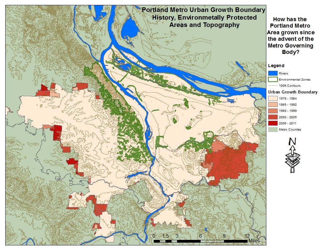
Portland's Urban Growth Boundary
Portland's Development

One final piece we need to embrace for this new housing to take hold is the urban growth boundary. Without restricting new construction to defined areas we will only continue to experience dangerous sprawl. Urban growth boundaries prevent greenfield development and encourage infill instead. The most famous American example of the growth boundary is in Portland, Oregon, but even that is too loose as most of the area inside the boundary is occupied by single-family only zoning and has been expanded fairly routinely. To give you an idea, Portland’s density (4,740 people per sq. mile) is still significantly less dense than that of Syracuse (yet it also has some of the highest bike ridership numbers in the country, proving that intense density is not needed for a bikeable city). Every Rust Belt city, and more importantly its metropolitan area, should have a growth boundary as populations have stagnated or declined. To have new development further away from the city without an increase in population is irresponsible environmentally and economically. It should also be significantly easier to implement in such cities, as opposed to many of the faster growing cities across the country (although it’s even more important to implement in those cities now rather than later). 

When you combine all of these policies you begin to open the door to more housing at all income levels while reducing the environmental strain. When paired with the many transportation policies already discussed in this series you begin to see a more sustainable way forward with comfortably dense communities built around walking, cycling, and transit use. This is a vision that is increasingly seen as the way out of the current pandemic without doubling down on the failures of auto oriented development of the last century.

In Climate Crisis, Urban Planning, Housing Tags Climate Crisis
Comment
← Newer Posts

Recent posts

Featured
Carousel.jpg
May 27, 2025
Destiny USA and the City
May 27, 2025
Read More →
May 27, 2025
PXL_20240805_141743149.jpg
Jan 1, 2025
All Cities Are Beautiful
Jan 1, 2025
Read More →
Jan 1, 2025
PXL_20241005_135224129.jpg
Nov 6, 2024
A Healthy Future for the Regional Market
Nov 6, 2024
Read More →
Nov 6, 2024
PXL_20240728_191254239.jpg
Jul 31, 2024
Renters Matter, Too
Jul 31, 2024
Read More →
Jul 31, 2024
Vista view.jpeg
Mar 21, 2024
The Valley of the Sun - A Land of (Sub)Urban Extremes
Mar 21, 2024
Read More →
Mar 21, 2024
Manlius Cinema.jpeg
Jan 31, 2024
The Movie Theater at the Urban Core
Jan 31, 2024
Read More →
Jan 31, 2024
Clinton Square Christmas Tree at night.jpeg
Nov 30, 2023
The Case for a Holiday Village
Nov 30, 2023
Read More →
Nov 30, 2023
PXL_20230817_220739294.jpg
Oct 31, 2023
The Walk: To Middle Ages
Oct 31, 2023
Read More →
Oct 31, 2023
Ballpark.jpeg
Sep 7, 2023
The Walk: To the Ballpark
Sep 7, 2023
Read More →
Sep 7, 2023
PXL_20230813_213112525.jpg
Aug 14, 2023
The Walk: To Tipperary Hill
Aug 14, 2023
Read More →
Aug 14, 2023
Arts and Crafts Festival 2023.jpeg
Jul 31, 2023
The Walk
Jul 31, 2023
Read More →
Jul 31, 2023
PXL_20230515_144325643.jpg
Jun 21, 2023
Lessons from the North
Jun 21, 2023
Read More →
Jun 21, 2023

Powered by Squarespace